- News
- India News
- Cylcone Titli: Storm may hit Odisha, coastal Andhra Pradesh; heavy rains expected
Trending
This story is from October 9, 2018
Cylcone Titli: Storm may hit Odisha, coastal Andhra Pradesh; heavy rains expected
The Indian Meteorological Department (IMD) on Monday said a depression over the Bay of Bengal is likely to concentrate into a cyclonic storm during the next 48 hours.
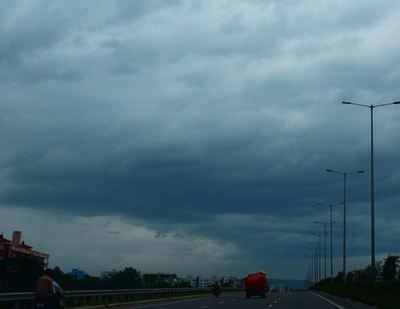
NEW DELHI: The Indian Meteorological Department (IMD) on Monday said a depression over the Bay of Bengal is likely to concentrate into a cyclonic storm during the next 48 hours.
Under its impact, several parts of Odisha and Andhra Pradesh will receive heavy rainfall starting from October 9. The cyclone has been named ‘Titli’ and is predicted to be of a strength that could be fatal to people and property.
CYCLONE TITLI MAY HIT COASTAL ANDHRA PRADESH
A cyclone is expected to hit the coastal parts of north-coastal Andhra Pradesh on Thursday, according to the India Meteorological Department (IMD). This will be the second cyclonic storm in the Bay of Bengal this year. The first cyclone, called the ‘Daye’, hit Odisha last month.
ODISHA BRACES FOR STORM
A depression over the Bay of Bengal, which is expected to intensify into a cyclonic storm on Wednesday and bring heavy rain to many parts of Odisha, especially along the coast, has prompted the state government to cancel the holidays of emergency personnel.
The National Emergency Response Centre (NERC), which functions under the Union ministry of home affairs, on Monday sent an advisory to the chief secretary in which it asked the state government to monitor the depression over the Bay, which is expected to intensify into a cyclonic storm. "It is very likely to move north-westwards towards Odisha and the adjoining north Andhra Pradesh coast in 72 hours," the advisory added.
State relief commissioner Bishnupada Sethi said the government was ready for any emergency. "Where the storm will make its landfall will be known on Tuesday. We are in touch with the Indian meteorological department (IMD). The government will issue an alert to all the districts as soon as it gets a signal from the IMD," Sethi said.
"The depression is likely to intensify into a deep depression and trigger heavy rainfall across Odisha on October 10 and 11," said director of IMD's Bhubaneswar centre, HR Biswas. "The wind speeds are likely to increase gradually to 70-80 kmph, before peaking to 90 kmph from Wednesday evening, along and off south Odisha and coastal north Andhra Pradesh," he added.
The IMD's Bhubaneswar centre has issued a 'red warning' for heavy to very heavy rain at a few places in the state and extremely heavy rain over the districts of Gajapati, Ganjam, Puri, Jagatsinghpur and Kendrapada on Wednesday and Thursday.
The sea condition is likely to be very rough between Tuesday and Thursday. Those out in the deep seas have been advised to return by Monday night. Distance cautionary signal no. 1 has been sounded in all ports of the state.
Under its impact, several parts of Odisha and Andhra Pradesh will receive heavy rainfall starting from October 9. The cyclone has been named ‘Titli’ and is predicted to be of a strength that could be fatal to people and property.
CYCLONE TITLI MAY HIT COASTAL ANDHRA PRADESH
A cyclone is expected to hit the coastal parts of north-coastal Andhra Pradesh on Thursday, according to the India Meteorological Department (IMD). This will be the second cyclonic storm in the Bay of Bengal this year. The first cyclone, called the ‘Daye’, hit Odisha last month.
According to the present track of the weather system, it was identified as a ‘‘depression” , or a lower grade of the cyclone, on Monday over the Bay of Bengal. The depression could intensify into a cyclone on Wednesday, and hit the coast on Thursday, the IMD said.
ODISHA BRACES FOR STORM
A depression over the Bay of Bengal, which is expected to intensify into a cyclonic storm on Wednesday and bring heavy rain to many parts of Odisha, especially along the coast, has prompted the state government to cancel the holidays of emergency personnel.
The National Emergency Response Centre (NERC), which functions under the Union ministry of home affairs, on Monday sent an advisory to the chief secretary in which it asked the state government to monitor the depression over the Bay, which is expected to intensify into a cyclonic storm. "It is very likely to move north-westwards towards Odisha and the adjoining north Andhra Pradesh coast in 72 hours," the advisory added.
State relief commissioner Bishnupada Sethi said the government was ready for any emergency. "Where the storm will make its landfall will be known on Tuesday. We are in touch with the Indian meteorological department (IMD). The government will issue an alert to all the districts as soon as it gets a signal from the IMD," Sethi said.
"The depression is likely to intensify into a deep depression and trigger heavy rainfall across Odisha on October 10 and 11," said director of IMD's Bhubaneswar centre, HR Biswas. "The wind speeds are likely to increase gradually to 70-80 kmph, before peaking to 90 kmph from Wednesday evening, along and off south Odisha and coastal north Andhra Pradesh," he added.
The IMD's Bhubaneswar centre has issued a 'red warning' for heavy to very heavy rain at a few places in the state and extremely heavy rain over the districts of Gajapati, Ganjam, Puri, Jagatsinghpur and Kendrapada on Wednesday and Thursday.
The sea condition is likely to be very rough between Tuesday and Thursday. Those out in the deep seas have been advised to return by Monday night. Distance cautionary signal no. 1 has been sounded in all ports of the state.
End of Article
FOLLOW US ON SOCIAL MEDIA


Hot Picks
TOP TRENDING
Trending Stories
In India
Entire Website
- UP: RPF cop saves man from coming under train at Prayagraj railway station
- Navi Mumbai man cheated of Rs 45.69 lakh in share trading fraud
- Salman Khan house firing case: Mumbai court sends both shooters to 10-day police custody
- Viral video: Gold & silver pani puri what? You heard it right
- 'BCCI needs to enforce Sale of RCB'
- Lok Sabha Elections 2024 in Rajasthan: Schools and colleges will remain closed on these dates
- Lok Sabha Elections 2024 in Tamil Nadu: Schools and colleges to remain closed on this date
- Patanjali ads case: You are doing good work but can't degrade allopathy, SC tells Ramdev
- These routes in India have base airfares of less than Rs 1,000! One route has a base fare of Rs 150 - check list
- Lok Sabha Elections 2024 in Telangana
- 'You are not so innocent': SC asks Ramdev to issue public apology in Patanjali ads case
- Isro achieves breakthrough with nozzle for rocket engines
- How SC could save India's oldest mountain forest
- UPSC results out: Aditya Srivastava tops Civil Services Exam 2023
- Salman house firing: Court sends both shooters to 10-day custody
- Pathan on why Karthik is unlikely to play T20 World Cup
- Why Israel and US don't want a direct war with Iran
- TCS has set this record for new orders first time in company's history
- Iran warns Israel against 'slightest' response to weekend attack
- Watch: UP cop saves man from coming under train

Popular Categories
Hot on the Web
Top Trends
Trending Topics
Bade Miyan Chote Miyan CollectionSalman Khan Firing NewsSalman Khan HouseSuchitra KrishnamoorthiNora FatehiMaidaan Movie CollectionArulmani Death NewsNavratri ColoursChamkila Movie ReviewKapil SharmaRanbir KapoorTamannaah BhatiaHimachal Day 2024Sara Ali KhanKiara AdvaniNita AmbaniBest Phones Under 50000Best Electric Cars For KidsBest Comforter SetsBest 65 Inch Tv
Living and entertainment
Latest News
UPSC Civil Services 2023 Final result out: Check direct link to download and toppers' list hereA spiritual sojourn for Ranveer Singh and Kriti Sanon in VaranasiIPL Match Full Schedule 2024: Team, Venue, Date & Time - Everything you need to knowHardik Pandya's inclusion in T20 World Cup squad depends on IPL bowling performance: ReportHardik Pandya's inclusion in T20 World Cup squad depends on IPL bowling performance: ReportLee Eun Joo, wife of Shinhwa's Andy, stands up against online abuseBengaluru’s electoral tapestry woven by migrants influxDiscover 10 official Manga apps offering English translationsDid you know Tamannah Bhatia was rejected by Jaaved Jaaferi on the dance show 'Boogie Woogie'?UP brand of administration key highlight of CM Yogi Adityanath rallies in other statesViral video: Gold & silver pani puri what? You heard it rightBJP’s ‘Viksit Bharat’ campaign took ‘Brand Modi’ to UP’s 20% populationJayant Chaudhary: The making of a Jat leader'Half of them don't even understand English': Virender Sehwag lambasts RCB managementWakefit co-founder's clever 'ad twist' to Narayana Murthy's '70 hours work week call''Mehsampur' director recalls meeting one of 'Amar Singh Chamkila’s alleged killers; says, 'I got an insight into...'No arms in Ram Navami rallies, 3,000 cops to be on Kolkata roadsIndian holding permanent residency in Japan arrives in Salem to campaign for BJP
Copyright © 2024 Bennett, Coleman & Co. Ltd. All rights reserved. For reprint rights: Times Syndication Service