- News
- City News
- kolkata News
- GSI designs app-based landslide warning for Darjeeling villages
Trending
This story is from October 23, 2018
GSI designs app-based landslide warning for Darjeeling villages

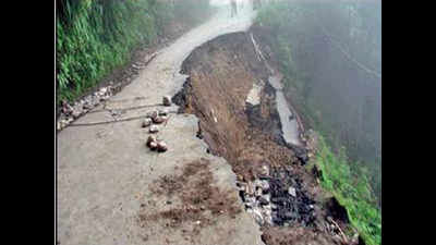
Geological Survey of India scientists say some of the worst landslides in the Darjeeling area (2016 photo above) have happened at night, aggravating the loss to life and property
KOLKATA: People in the three most landslide-prone villages in the country will now be alerted by WhatsApp messages and sirens on phone apps at the slightest signals of landslides.
The Geological Survey of India has developed a “people-centric” Landslide Early Warning (LEW) for Giddapahar, Paglajhora and 14th Mile villages, which it had earlier marked among the country’s most landslide-prone zones.The LEW is connected to mobile apps for fast and mass dissemination.
The system has been installed by GSI in the chosen villages, all in Kurseong block of Darjeeling, along with the district administration. The system has started working. The loss of life and property in the three villages due to landslides since 2003 has been immense and hence GSI decided to instal the system here first.
“Most landslides are rainfall-triggered and earlier we had a top-down system, where the administration was alerted first and then it trickled down to the population. But we wanted to change this because we thought that a bottom-up approach, where possible victims are alerted as soon as there is a trigger, will save more lives,” said Ashish Nath, director of GSI.
Shallow, fast-moving rainfall-induced landslides are one of the most common that kill several people every year in these villages and that had induced the GSI to study the pattern of landslides.
There are 18 such zones that the GSI has marked as extremely vulnerable and the three Darjeeling villages, where the warning system has been installed, top that list. The area has been studied using the latest In-SAR technology (Interferometric synthetic aperture radar), used for remote sensing, by putting five corner reflectors, rainfall threshold analysis for landslide initiation within the Kurseong area and finally the results culminated into development of the LEW.
The Geological Survey of India has developed a “people-centric” Landslide Early Warning (LEW) for Giddapahar, Paglajhora and 14th Mile villages, which it had earlier marked among the country’s most landslide-prone zones.The LEW is connected to mobile apps for fast and mass dissemination.
The system has been installed by GSI in the chosen villages, all in Kurseong block of Darjeeling, along with the district administration. The system has started working. The loss of life and property in the three villages due to landslides since 2003 has been immense and hence GSI decided to instal the system here first.
“Most landslides are rainfall-triggered and earlier we had a top-down system, where the administration was alerted first and then it trickled down to the population. But we wanted to change this because we thought that a bottom-up approach, where possible victims are alerted as soon as there is a trigger, will save more lives,” said Ashish Nath, director of GSI.
The villages are located over the crown of an active rock slide, which reactivated several times in the two decades. The houses and grounds have developed cracks and show signs of active mass movement, he added.
Shallow, fast-moving rainfall-induced landslides are one of the most common that kill several people every year in these villages and that had induced the GSI to study the pattern of landslides.
There are 18 such zones that the GSI has marked as extremely vulnerable and the three Darjeeling villages, where the warning system has been installed, top that list. The area has been studied using the latest In-SAR technology (Interferometric synthetic aperture radar), used for remote sensing, by putting five corner reflectors, rainfall threshold analysis for landslide initiation within the Kurseong area and finally the results culminated into development of the LEW.
End of Article
FOLLOW US ON SOCIAL MEDIA


