- India
- International
Friday, Apr 19, 2024
Journalism of Courage
 The IMD and other institutes of the Ministry of Earth Sciences ran data through 10 specialised weather models.
Thirteen days before cyclone ‘Fani’ hit the Odisha coast, the IMD had an indication that the low pressure in the Bay of Bengal and the Equatorial Indian Ocean could balloon into a massive storm and started preparing for the onslaught, the weatherman said.
On April 21, based on data from various sources, the India Meteorological Department (IMD) forecast that conditions were conducive for formation of a low-pressure area in the Equatorial Indian Ocean and south Bay of Bengal.
A low-pressure area is the initial stage of the formation of a cyclone.
Armed with data from different institutes of the Ministry of Earth Sciences (MoES), the meteorologists deliberated on how low pressure could pan out to be.
The IMD and other institutes of the Ministry of Earth Sciences ran data through 10 specialised weather models.

“We realised all the models suggested that it was going to turn into a cyclone. So, from April 25 we started issuing special bulletins,” IMD’s Additional Director General (services) Mritunjay Mohapatra told PTI.
Mohapatra, a veteran in tracking cyclones, played a critical role in tracking Fani’s progress and accurately predicting its path.
Elaborating on the formation stage of cyclone ‘Fani’, he said help from other institutes of the MoES played a crucial role in predicting the development of the cyclone.
The National Institute of Ocean Technology (NIOT), Chennai has over 20 buoys in the Bay of Bengal and the Arabian Sea that collected data on rainfall, temperatures below the sea and above, wind speed, Mohaptara said.
Different satellites provided data and images on clouds in oceanic area for monitoring low pressure systems, said IMD’s Director General K J Ramesh.
Satellite data was also used in running the models.
“There are island observatories that fed us with data,” Mohapatra said.
Ramesh said data was processed under different weather models by the Indian Institute of Tropical Meteorology (IITM), Pune and National Centre for Medium Range Weather Forecasting (NCMRWF), Noida. These two institutes have two supercomputers that process data.
The data was further processed by the Indian National Centre for Ocean Information Services (INCOIS), Hyderabad that gave predictions on the extent, depth and duration of the inundations in the low-lying areas due to the cyclone, Ramesh said.
A similar model is run by Indian Institute of Technology Delhi to help the IMD with information on inundation.
The IMD also used its radars at Chennai, Karikal, Machilipatnam, Visakhapatnam, Gopalpur, Paradip, Kolkata, Agartala to the fullest.
“Twelve hours before the landfall, we kept sending updates on locations to concerned states every half hour using our radars, besides releasing hourly bulletins,” Ramesh said.
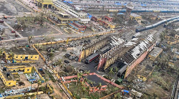
‘Fani’ intensified into a cyclone on April 27. It became a ‘severe cyclonic storm’ on April 29 and into a ‘very severe cyclone’ on April 30. A day later, it took the from of an ‘extremely severe cyclone’ and slammed into the Odisha coast on May 3 with a speed gusting to 175 kilometres per hour.
Cyclone ‘Fani’ ravaged most parts of Odisha and left 12 people dead, a senior official had said.
The IMD also earned praised from different quarters of the world for its predictions.

Congress councillor's daughter stabbed to death by classmate at college premises in Karnataka. CCTV footage shows accused, Fayaz, repeatedly stabbing Neha Hiremath before fleeing. Police have detained Fayaz, a resident of Savadatti, and are investigating the motive. Accused had stopped attending college after failing an exam six months ago.