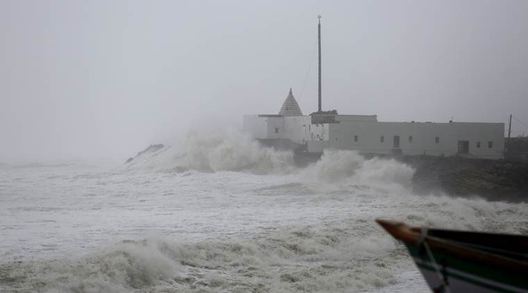
 Waves crash on the coast of the Arabian Sea in Veraval, Gujarat, Thursday. (AP)
Weather Forecast, Cyclone Vayu HIGHLIGHTS: Cyclone Vayu moved away from Gujarat coast on Thursday and changed its course towards Oman, in a relief for the state which has put in place elaborate security measures and disaster management mechanisms to tackle the storm. The “very severe” cyclonic storm will not make landfall in Gujarat as it has moved towards the sea, IMD had announced earlier this morning.
On Thursday, in a massive evacuation drive, around three lakh people were shifted to safer places as the cyclonic storm Vayu inched closer to the Gujarat coast. It was expected to make landfall between Dwarka and Veraval this afternoon. Schools and colleges will remain shut on June 12 and 13 across 10 districts as the Army, NDRF personnel, IAF helicopters and around 300 marine commandoes remain on standby to overlook rescue and relief operations.
On Wednesday, Chief Minister Vijay Rupani held a review meeting to monitor the situation. Flight operations were suspended by the Airports Authority of India in Porbandar, Diu, Bhavnagar, Keshod and Kandla for 24 hours from Wednesday midnight. The railways has cancelled 86 trains and short terminated 37 others due to the cyclone, reports PTI. Likewise, the Gujarat Maritime Board has also suspended all shipping activities across the Gulf of Khambhat and shifted over 1,600 workers, including those at the Alang shipbreaking yard and the Chara port. The RO-PAX ferry service, between Dahej and Gogha, located across the Gulf of Khambhat was also suspended, sources said on Wednesday.
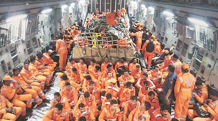 NDRF members inside an IAF C-17 aircraft as it lands in Jamnagar, Gujarat. The team will carry out relief and rescue missions for those affected by Cyclone Vayu. (PTI Photo)
Though Gujarat has been spared by Cyclone Vayu, Rajkot district administration will prepare one lakh food packets and send them to Porbandar for distribution among people evacuated to shelters. Though the "eye of the storm" is away from land, the cyclone's outer periphery would leave its impact on the coast, officials said after they had evacuated nearly three lakh people from the coastal areas.
The Airports Authority of India reviewing the status of its airports in Gujarat in the wake of Cyclone Vayu, issued a statement and said that normal flight operations would resume at Kandla and Keshod airports today from 12 am whereas, at Bhavnagar airport from 6 am tomorrow. It also said that flight services at Diu and Porbandar airports would also resume tomorrow morning.
News agency ANI quoted Gujarat Chief Minister Vijay Rupani as saying that the cyclone which was going to hit Gujarat has moved towards Oman. "But still for 24 hrs administration will be on high alert, schools of 10 districts will stay closed tomorrow," he said.
Police have declared Chowpaty at Porbandar off-limits for general public due to very high tide in the sea while cyclone Vayu whizzes past Saurashtra coast.
Iqbal Singh Chauhan, DIG of Coast Guard, Porbandar, on Thursday said that the force has been monitoring the situation since last Saturday. "We took pre-emptive actions and ensured that there are no fishermen or boats out in the sea. We are monitoring the current situation and are fully prepared," he told ANI.
As it rains and gusty winds blow under the influence of cyclone Vayu near coastal Mangrol town of Junagadh district, here's a picture of a shepherd struggling to keep his herd of goats together.
Power supply has been disrupted in nearly 560 villages of Gujarat due to cyclone Vayu and all efforts are on to restore it, an official said on Thursday. The Gujarat Urja Vikas Nigam Limited (GUVNL) chalked out an action plan well in advance in view of the cyclone threat, the state government-promoted company's in-charge managing director Shahmeena Husain told PTI.
"Around 561 feeder lines in Saurashtra and south Gujarat are affected due to the impact of cyclone Vayu. We are confident that the power supply will be restored soon in the 560 affected villages," she said.
NDRF has rescued a pregnant woman requiring pre-term delivery from Shiyalbet village,where boats are the only mode of transport. The team brought her to a hospital in Jafarabad. The woman successfully delivered a baby boy. Condition of both the child and the mother is stable.
Western Railway announced Thursday that nine more trains have been cancelled, and another four short terminaated with partial cancellation as a precautionary measure in view of the cyclone.
Prime Minister Narendra Modi today assured all possible aid to the state government. "PM Modi held telephonic talk with Gujarat CM Vijay Rupani on cyclone preparedness immediately after reaching Bishkek and assured all assistance and support from the central government to mitigate the effects of Cyclone Vayu," the Chief Minister's Office tweeted.
Defence Minister Rajnath Singh reviewed the preparations of the Indian Coast Guard and Navy for tackling the cyclone and is also monitoring the situation, ANI reported.
The impact of cyclone Vayu has been milder at most airports in Gujarat and there has been no damage to aerodromes' infrastructure so far, Airports Authority of India said. "No damage to any airport infrastructure or facilities has been reported so far. The situation is normal at Surat, Bhuj, Keshod, Kandla, Jamnagar, Vadodara and Ahmedabad, Diu, Porbandar and Bhavnagar airports," it said in a statement.
No casualty has been reported so far due to the cyclone, he said. "People have been advised to stay away from the coast. The situation is still critical. All the ports have been asked to hoist the storm warning signal number 9. Many areas near the coast are now receiving rain. The cyclone may bring very heavy to extremely heavy rain in some areas," Pankaj Kumar said.
Cyclone Vayu, which has turned into a "very severe cyclonic storm", was earlier expected to make landfall on the Gujarat coast this afternoon, but as per the latest weather report, the storm is around 150 km away from Veraval, in the coastal district of Gir Somnath. The cyclone will move north-northwestwards, brushing past the Saurashtra coast, instead of making landfall, the report said.
The effect of cyclone Vayu has been milder across most of the airports in Gujarat, ANI reported. No damage to any airport infrastructure or facilities has been reported so far. The situation is normal at Surat, Bhuj, Keshod, Kandla, Jamnagar, Vadodara, Ahmedabad. Diu, Porbandar and Bhavnagar airports, that are currently witnessing a wind speed of 30-40 kmph, gusting up to 60 kmph ,have been asked to closely monitor the situation and take note of the meteorological data.
"No casualties have been recorded due to Cyclone Vayu till now. The deaths (six in the last 2 days) are not due to the cyclone, rather it is due to the monsoon," Pankaj Kumar told ANI. In various rain-related incidents, five people were killed due to lightning on Tuesday while one person was killed after a tree fell on him. Click here to read more.
After two gusty days in the city, Thursday is expected to be calmer with the winds slowing down, according to the weather forecast. As Cyclone Vayu moved towards Gujarat passing the Maharashtra coast, wind speeds along the state coast ranged from 60-70 kmph on Wednesday, and are expected to further slow down on Thursday. The IMD forecast light to moderate showers and thunder. While the promenades at Nariman Point, Worli and Bandra saw expected crowds through the day, police made regular announcements for people not to stand too close, owing to high waves. The maximum temperature in the city fell to 34.6 degrees on Wednesday with heavy rain showers in parts of the city. Colaba recorded 13 mm of rainfall while Santacruz recorded 7 mm of rainfall. Humidity remained high at 81 per cent in Colaba and 64 per cent in Santacruz. IMD officials said thunder and rain showers are likely over the next three days in Thane, Palghar and Mumbai. Click here to read more.
The IMD has also announced severe heat wave conditions in isolated pockets over Madhya Pradesh and Vidarbha. It has predicted heatwave to severe heatwave in isolated areas in Jharkhand, Marathwada, Chhattisgarh and Telangana.
On weather conditions in other areas, the IMD has predicted heavy to very heavy rainfall at isolated areas, likely over Kerala. Heavy rainfall has also been predicted over Tamil Nadu, coastal Karnataka, Arunachal Pradesh, Nagaland, Manipur and Tripura.
The Veraval-Amreli, Amreli-Junagadh, Delvada-Veraval are some of the trains that were cancelled for Wednesday and Thursday. The Western Railway has also decided to run special relief trains. Two such special evacuation trains have been run in Rajkot division and one in Bhavnagar division to clear passengers from coastal area that are affected by the cyclone.
The Goa Tourism Development Corporation (GTDC) has sought a report over some cruise ships operating in the Mandovi river in Panaji, located close to the Arabian Sea, despite a warning of rough weather along the state coast due to cyclone Vayu, an official said. The GTDC received complaints that some cruise vessels were operating close to the sea waters, the state-run entity's chairman, Dayanand Sopte, had said on Wednesday. "I have asked the officials concerned to submit a report to me in two days on how the cruise ships were allowed to leave the jetty and venture into the water," he said.
In Odisha, according to Skymet Weather, few spells of rain and thundershowers associated with lightning likely to continue over multiple districts of Odisha in the next six-eight hours.
The railways has cancelled 77 trains and short terminated 33 others due to Cyclone Vayu, the Western Railways said today. "Considering the alertness for Cyclone Vayu over Gujarat, the Western Railway has decided to fully cancel the operation of 77 mainline trains, while 33 other mainline trains have been short terminated with partial cancellation as a precautionary measure in the cyclone-prone areas. In addition to this, various safety and security precautions are also being taken by the Western Railway for train passengers of these prone areas under the jurisdiction of WR -- Veraval, Okha, Porbandar, Bhavnagar, Bhuj and Gandhidham," the railways said.
In Rajasthan, the weather body has predicted dust storm and a few spells of thundershower with strong winds across multiple districts in the next 12-18 hours, Skymet Weather reported.
Meanwhile, according to Skymet Weather, the coastal areas of Karnataka are likely to be affected by rain and thundershower while light to moderate rain and thundershower are expected over multiple districts of interior areas in the next 24-36 hours.
The severity of Cyclone Vayu remains a threat for Gujarat's coastal areas even though it has changed course and is unlikely to make landfall in the state, an IMD official said. "The threat of surge in wind, dust storm and rainfall stays very much. The centre of the storm -- known as the eye -- has slightly moved away from the Gujarat coast, but its diameter is well over 900 km," the official said.
"The very severe cyclonic storm “Vayu” is very likely to move north-northeastwards for some time and then northwestwards, skirting the Saurashtra coast, affecting Gir, Somnath, Diu, Junagarh, Porbandar and Devbhoomi Dwarka with wind speed 135-145 kmph, gusting to 160 kmph from afternoon of 13th June 2019," the IMD said in its latest bulletin.
"The windspeed has reduced to of 65 kmph (approx) and all boats in harbour safe," the Indian Coast Guard tweeted.
Speaking to reporters in Ahmedabad, the meteorological department's Additional Director Manorama Mohanti said the direction has "slightly" changed. "The 'very severe' cyclonic storm Vayu will not make landfall on the Saurashtra coast, but it will skirt the coast and affect Gir-Somnath, Junagadh, Porbandar, Devbhoomi-Dwarka districts and Union Territory Diu," she said. "The eye of the storm will not enter Gujarat, but half of the storm, the outer peripheral part, will enter the state and affect the coastal areas," Mohanti said.
IMD Additional Director General Devendra Pradhan said the cyclone will remain in the sea and move parallel to the Gujarat coast. "It has taken a slight westward movement. It will move parallel to the Gujarat coast," he said.
"It (cyclone Vayu) may not make landfall. It will only skirt the coast. It has made a small deviation. But, its effect will be there with strong winds and heavy rain," Secretary at the Ministry of Earth Sciences M Rajeevan told PTI.
"Cyclone ‘VAYU’ over Arabian Sea at 0530 hrs IST of today, the 13th June, 2019 about 150 km south-southwest of Diu, 110 km southwest of Veraval (Gujarat) & 150 km south of Porbandar (Gujarat). To skirt Saurashtra coast with wind speed 135-145 kmph from today afternoon," the IMD said. (Twitter/@Indiametdept)
"The Gujarat government's alertness for Cyclone Vayu continues with the same intensity. The persons shifted to shelter homes will stay there. People should continue to stay in safe areas. Their preparedness should continue at the same level. No movements in coastal areas. We shall continue to remain alert," Pankaj Kumar, ACS, Revenue, said.
Rain and high-speed wind were witnessed in the coastal area of Veraval in Gujarat on Thursday morning. (Express photo/Javed Raja)
Coming as a respite after a period of severe hot weather, Pune and its surrounding regions are likely to experience cloudy skies and scanty rain in the next few days. This is mainly a fallout of the severe cyclonic storm Vayu at present hovering near the Mumbai coast. Dr A Kashyapi, head, weather monitoring and air pollution, IMD said heavy cloud cover will be reported in next 48 hours in Pune. Click here to know more.
IMD, Ahmedabad, regional director Jayanta Sarkar confirmed to The Indian Express that cyclone Vayu will not hit Gujarat but inclement weather would be witnessed across the coastal belt with high-velocity winds, high tides and rainfall.
Six NDRF teams are on alert in Porbandar. As per latest IMD update, Cyclone Vayu will have an effect on coastal areas.
"Very Severe Cyclonic Storm Vayu to skit along Saurashtra Coast this afternoon with a wind speed 135-160 kmph. Coastal districts Diu, Gir Somnath, Junagarh, Porbandar, Dwarka will be affected," scientist Mohanty said.
In the IMD bulletin, fishermen have advised not to venture into north Arabian sea and along and off Gujarat coast till June 15 and over the eastcentral Arabian Sea and along and off Maharashtra Coast today.
Cyclone Vayu moved north-northwestwards with a speed of 12 kmph and lay centred at 11:30 pm on Wednesday. (IMD website)
Meanwhile, beaches in Konkan region have been closed for the public in view of the cyclone warning. "The extent of the cyclone is over 900 km. So while the eye of the cyclone may or may not hit Porbandar, the system will still hit. Accompanying risk factors such as wind and storm surge and rainfall, all the three continue to remain as threat factors. Hence, please don't relax in preparedness," the IMD office in Mumbai said.
Latest track of Cyclone Vayu which shows it will not hit Gujarat. (Twitter/@SkymetWeather)
As per weatherman, the Skymet Weather reported, the reason behind the change in the track is that Cyclone Vayu would encounter with weak steering environment. As the system curves north-northwest, the speed of the system would become slow. After crossing the Gujarat coast, Vayu would encounter an anti-cyclone over North Arabian Sea. As a result, the system might become stagnant near Karachi Coast. There are chances that Vayu may not make landfall and weaken in the sea itself.
Devotees visited Somnath Temple this morning despite a Cyclone Vayu alert.
Manorama Mohanty, a scientist at IMD, Ahmedabad, told ANI, "Cyclone Vayu won't hit Gujarat. It will pass nearby from Veraval, Porbandar and Dwarka. Its effect will be seen in the coastal regions as there will be heavy wind speed and heavy rain as well."
Meanwhile, Gujarat minister Bhupendrasinh Chudasama said the Somnath Temple cannot be closed even in the wake of a cyclone alert. "Temples cannot be closed. We have requested tourists not to visit but 'aarti' will be performed and will not be stopped. This (cyclone Vayu) is a natural disaster and only nature can stop it. Who are we to stop the nature," he told ANI.
In its bulletin, the weather department has predicted widespread rainfall with heavy to very rainfall at few places and extremely heavy downpour at isolated places at Saurashtra and Kutch regions. In Gujarat, the IMD forecast rainfall at a few places with heavy downpour at isolated areas.
Cyclone Vayu likely to move north-northwestwards for some time and then northwestwards skirting the Saurashtra coast affecting Gir Somnath, Diu, Junagarh, Porbandar and Devbhoomi Dwarka with wind speed 135-145 kmph, gusting to 160 kmph, from this afternoon, the IMD bulletin read. It added, "Gale wind speed of the order of 135-145 kmph gusting to 160 kmph very likely over north Arabian Sea and Gujarat coast. It is very likely to be 50-60 kmph, gusting to 70 kmph over north Maharashtra Coasts and northern parts of east central Arabian Sea."
According to Skymet Weather, Cyclone Vayu may not hit Gujarat and drift away from the Saurashtra coast. Weather models are indicating that there is a fair amount of probability that very severe cyclone Vayu may just skirt the Gujarat coast near Porbandar, close to Dwarka or Okha coast, Skymet Weather reported.
"VSCS VAYU over EC Arabian Sea moved NNW-wards in last six hours. It is 130 km SW of Veraval and 180 km S. Porbandar. It is likely to move NNW-wards for some time and then NW-wards skirting Saurashtra coast with wind speed 135-145 kmph from afternoon 13.06.2019," the IMD tweeted.
Preparations have begun to deal with the impact of Cyclone Vayu. In the below photos, various groups in Rajkot are preparing food packets for the cyclone-affected areas, as per instructions from government officials.
The shed at the entrance of the Somnath Temple, in Gir Somnath district, was damaged due to the impact of the strong winds.