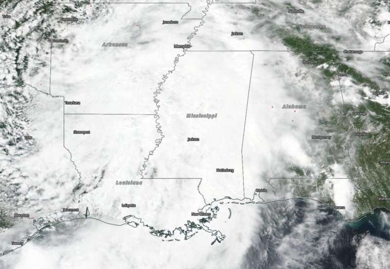
NASA-NOAA satellite tracking Barry through Louisiana, Arkansas

Barry, now a tropical depression, continues moving slowly north through Arkansas and rainfall and flooding remains a concern. NASA-NOAA's Suomi NPP satellite passed over the south central United States yesterday, July 14 and captured a visible image of then Tropical Storm Barry.
Tropical Storm Barry tracked through northwestern Louisiana on July 14, and weakened to a tropical depression. On its track, Barry dropped up to 15 inches (38 cm) of rain in some isolated placed. Barry's rainfall created flooding along the Mississippi River.
The Visible Infrared Imaging Radiometer Suite (VIIRS) instrument aboard Suomi NPP provided a visible image of the storm on July 14 after it moved inland over Louisiana. The VIIRS image showed an elongated storm over Louisiana stretching over the Mississippi River Valley and into Arkansas, Mississippi, western Alabama and southwestern Tennessee.
On July 15, NOAA's National Weather Service Weather Prediction Center in College Park, Maryland said that local flash flooding remains a likely threat through the day. Flash Flood Watches and Warnings are in effect for portions of far southeast Texas through much of Louisiana, Mississippi and Arkansas, and including parts of the mid-Mississippi Valley. Barry is expected to produce additional rain accumulations of 2 to 4 inches with isolated maximum amounts of 8 inches across Arkansas, western Tennessee and Kentucky, southeast Missouri, and northwest Mississippi.
At 5 a.m. EDT (0900 UTC), the center of Tropical Depression Barry was located near latitude 34.4 degrees north and longitude 93.5 degrees west. That's about 80 miles (125 km) west-southwest of Little Rock Arkansas. The depression is moving toward the north near 9 mph (15 kph) and this motion is expected to continue through today, before turning off to the northeast by Tuesday. Maximum sustained winds are near 25 mph (35 kph) with higher gusts. Little change in strength is forecast during the next 48 hours. The estimated minimum central pressure is 1008 millibars (29.77 inches).
In addition to the heavy rainfall, the National Weather Service noted, "A couple of tornadoes are possible today from the Mid-South toward the Lower Ohio Valley."
More information: For river flood forecasts, visit: https://water.weather.gov/ahps/
Provided by NASA's Goddard Space Flight Center


