 Cyclone Bulbul, Weather Forecast today HIGHLIGHTS: According to MeT, it is very likely to intensify further till earning morning of November 9. (Express File Photo: Partha Paul)
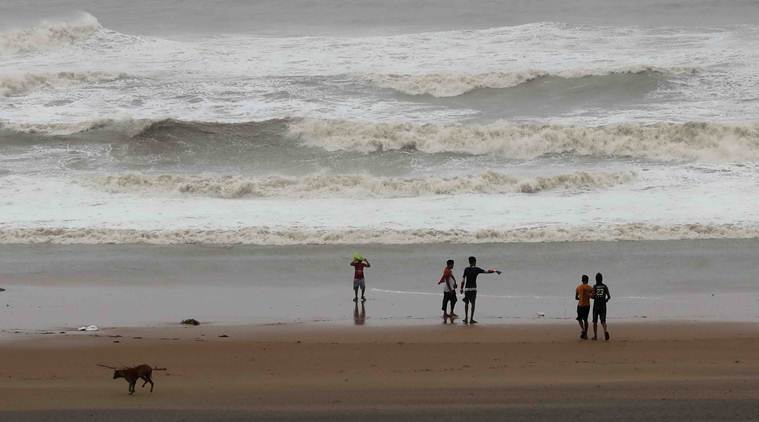
Cyclone Bulbul, Weather Forecast Today HIGHLIGHTS: Cyclonic storm ‘Bulbul’ Friday intensified into a ‘severe’ category cyclonic storm, the India Meteorological Department (IMD) said as it sounded a yellow alert in West Bengal and predicted heavy rainfall in some parts of the state.
Centred over west-central and adjoining east-central Bay of Bengal, about 310 km south-southeast of Paradip, the cyclone is likely to move towards West Bengal and Bangladesh coasts, skirting Odisha, HR Biswas, the director of Bhubaneswar Meteorological Centre, told news agency PTI on Friday.
The storm is currently moving at a speed of 13 kmph and may intensify further by Saturday. It is unlikely to make landfall in Odisha. Officials have been told to ensure total suspension of fishing operations from Friday. Farmers have also been advised to take steps to protect crops and harvested paddy.
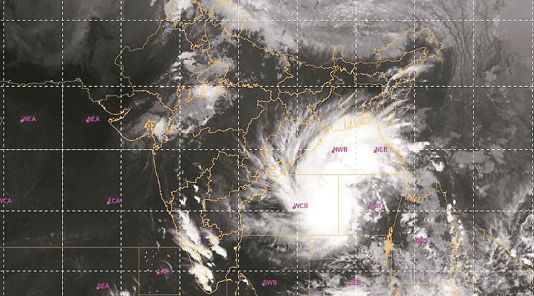 Cyclone Bulbul location on Thursday at 2:30 pm
The NDRF has stationed a total of 34 teams in West Bengal and Odisha in view of the approaching severe cyclone Bulbul, news agency PTI reported Friday. Seventeen teams each have been stationed in the two states and the National Disaster Response Force is prepared to tackle any eventuality.
The IMD has said the cyclone, which had developed over Bay of Bengal, has now intensified and is likely to cross the West Bengal coast by early Sunday morning.
Cold wave conditions intensified across Himachal Pradesh after fresh snowfall in the higher reaches and rain in several parts of the state on Friday, the meteorological department said.
Minimum temperatures decreased by 1 to 2 degrees Celsius in the state following the rain and snowfall on Friday, Shimla MeT Centre Director Manmohan Singh said. (PTI)
The National Crisis Management Committee (NCMC), headed by Cabinet Secretary Rajiv Gauba, on Friday took stock of the preparedness for rescue and relief operations for the severe cyclone 'Bulbul', which is likely to hit Odisha and West Bengal, news agency PTI reported.
During a meeting, the cabinet secretary directed central government agencies to provide immediate assistance to the state governments.
As per the latest bulleting issued by the IMD, Cyclone Bulbul lay about 500km south of Kolkata, 260 km south-southeast of Paradip (Odisha), 390 km south-southwest of Sagar Islands (West Bengal) and 510 km south-southwest of Khepupara (Bangladesh).
"It is very likely to move nearly northwards till 9th November morning. Thereafter, it is very likely to re-curve northeastwards and cross West Bengal- Bangladesh coasts," the IMD said.
The weather agency has also issued an Orange alert for West Bengal region. It forecast light to moderate rainfall at many places over coastal districts of West Bengal with heavy rain at one or two places very likely over North and south 24 Parganas and east Medinipur districts.
The Arabian Sea saw the formation of four cyclones in 2019, a phenomenon recorded after 117 years, according to meteorologists. This year, the sea that touches the Indian subcontinent, West Asia and West Africa, has seen the formation of Vayu, Hikka, Kyarr and Maha cyclones. (PTI)
Heavy snowfall across Kashmir severely affected essential services like electricity and water supply. The unseasonal snowfall has resulted in uprooting of trees and electric poles in many areas.
After heavy snowfall, Kashmir remained cut off from the rest of the country for the second day on Friday as the Jammu-Srinagar national highway was blocked while flights to Srinagar airport were suspended due to poor visibility.
Roads connecting the summer capital of the newly-formed union territory with far-flung areas like Gurez, Macchil, Keran and Tangdhar were also shut due to adverse weather conditions. (PTI)
Cyclone 'Bulbul', which has intensified into a very severe cyclonic storm, is likely to make landfall between West Bengal and Bangladesh in the early hours of Sunday, bringing in its wake heavy rain and gusts of up to 135 kmph in the coastal areas, the Met department said.
The weatherman said the severe cyclonic storm, which lay centred 600 km south of Kolkata on Friday morning, was expected to intensify further by Saturday and move northwards
Centred over west-central and adjoining east-central Bay of Bengal, about 310 km south-southeast of Paradip, the cyclone is likely to move towards West Bengal and Bangladesh coasts, skirting Odisha, HR Biswas, the director of Bhubaneswar Meteorological Centre, told news agency PTI on Friday. It is unlikely to make landfall in Odisha
Centred over westcentral and adjoining eastcentral Bay of Bengal, about 310 km south-southeast of Paradip, the cyclone is likely to move towards West Bengal and Bangladesh coasts, skirting Odisha, HR Biswas, the director of Bhubaneswar Meteorological Centre, told news agency PTI on Friday.
Power restoration work underway in Srinagar following heavy snowfall in the region.
As per IMD predictions, coastal Odisha is likely to experience wind speed of 70-80 kmph gusting up to 90 kmph on Friday accompanied by heavy to very heavy downpour, Special Relief Commissioner (SRC), PK Jena said. Earlier, the IMD had predicted light to moderate rainfall acompanied by wind with 40 to 50 kmph in north coastal Odisha under its impact, he said. Jena said the Prime Minister's office reviewed the situation through video-conference on Thursday. In view of rough weather, all schools and Anganwadis will remain closed on Friday and Saturday in Puri, Jagatsinghpur and Kendrapara districts, an official said.
Over 4,000 vehicles were left stranded as the arterial Jammu-Srinagar national highway remained closed for the second consecutive day following heavy snowfall and landslides which blocked vehicular movement at several places, officials said on Friday.
The Mughal Road, connecting the twin districts of Poonch and Rajouri in Jammu region with South Kashmir's Shopian district, was also closed for traffic for the third consecutive day on Friday after snowfall in the high altitude areas on Wednesday, officials said. (PTI)
The IMD recorded 0.2 mm rain in the Colaba observatory (in south Mumbai) and 32.6 mm rain in the Santcruz observatory (in suburbs) in the last 24 hours (from 8.30 am Thursday morning to 8.30 am Friday). However, road and rail transport remained unaffected by the downpour, a civic official said. Cyclone 'Maha' fizzled out into the Arabian Sea off the Gujarat coast on Thursday, causing moderate rainfall in several parts of Maharashtra.
Principal Secretary to the Prime Minister, P K Mishra in a high-level meeting on Thursday, assured the states all necessary central assistance required in the developing situation due to 'Bulbul'. He also advised the states to take all possible measures to ensure that there is minimum human casualty and loss to property, an official statement said. (PTI)
As the cyclonic storm 'Maha' weakened', it brought heavy to moderate rainfall in several parts of the city, suburbs of Thane and Navi Mumbai on Friday. Heavy showers lashed Mumbai suburbs of Ghatkopar, Chembur, Santacruz, Borivali, Kandivali and Malad in the early hours of Friday, an official said. At some places, showers were accompanied by lightning and thunder. Parts of adjoining Thane and Palghar districts also experienced showers, an offical in the district disaster management control room said.
Parts of adjoining Thane and Palghar districts also experienced showers, an offical in the district disaster management control room said. Low-lying areas in Thane and Palghar districts were water-logged, he said. According to reports, seashore villages of Dahanu, Chinchani, Boisar, Safale and Kelve in Palghar district received heavy showers. (PTI)
The air quality in Delhi kept continued to be in 'very poor' category on Friday morning because of high humidity, officials said. The air quality index (AQI) of Delhi was 350 at 9 am, according to Central Pollution Control Board (CPCB). An AQI between 201 and 300 is 'poor', 301-400 'very poor' and 401-500 'severe' while the AQI above 500 falls in the severe plus category. (PTI)
Jammu and Kashmir Chief Secretary B V R Subrahmanyam on Thursday called for joint control rooms to be made functional throughout the winter season to keep the public informed about adverse weather and issue alerts for potential avalanches, an official spokesman said. The chief secretary instructed the Kashmir divisional commissioner to share with the district administration, the names and contact details of the nodal officers designated for coordinating rescue and air operations, the spokesman said.
The chief secretary asked Disaster Management Relief, Rehabilitation and Reconstruction Department secretary to immediately liaise with principal secretary, civil aviation, on the commencement of air services to the snow-bound areas. He directed authorities to setting up a help desk at the Srinagar airport. (PTI)
The temperature in Delhi fell to 14 degrees Celsius on Friday due to rains in the past 24 hours, IMD officials said. The temperature recorded was four notches below the season's average, they said. A shallow fog also covered the city in the morning hours. The city received 8 mm rainfall till 8.30 am and relative humidity was 94 per cent. Acordimg to the Met department, the sky is likely to remain partly cloudy and the maximum temperature is expected around 28 degrees Celsius, the official said.
Rain lashes parts of Mumbai.
The weatherman said the system is likely to move initially north-northwestwards and then nearly northwards till November 9. It will then re-curve northeastwards towards Bangladesh and adjoining West Bengal, skirting Odisha, and cause heavy to very heavy rain in the coastal districts of North Odisha and West Bengal for three days from Friday. Forecast track and intensity are given in the following table.
(Source: IMD)
“The cyclone in Bay of Bengal will lead to an increase in moisture incursion over the west coast, keeping temperatures high till November 21, as it will cut the flow of dry and cool winds from the northern parts of the country,” said an IMD official. The IMD said the average minimum temperature across Maharashtra generally drops to 13-14 degrees Celsius in the first ten days of November.
As predicted by the IMD, Rajouri in Jammu and Kashmir receives snowfall. The Met department had predicted heavy to very heavy rain/snow at isolated places over Jammu & Kashmir and Himachal Pradesh under the influence of western disturbance and its interaction with the remnant of cyclone ‘Maha’.
In Rameswaram, Pamban Port Storm Perilous Alert No 2 Cage mounted at Pamban bridge, in the view of severe cyclonic storm 'Bulbul'. According to IMD, severe cyclonic storm #Bulbul to intensify further till 9th November. (ANI)
The onset of winter in Maharashtra will be delayed by at least two weeks as Cyclone Bulbul in the Bay of Bengal is set to increase the moisture incursion over the west coast, cutting off the flow of dry and cool winds from north India, the India Meteorological Department said.
On Thursday morning, the deep depression intensified into a cyclonic storm, and it will further strengthen to a severe cyclonic storm over the next 24 hours, moving west-northwestward to Odisha, West Bengal and Bangladesh. A weather depression had developed over the southeast Bay of Bengal and north Andaman Sea from Wednesday. Read more
According to the latest bulletin released by IMD, Alipore, heavy rains of 7-11 cm is likely at one or two places over North &andsouth 24 Parganas and east midnapore districts on Friday. Heavy to very heavy rainfall is likely to occur at one or two places over North and South 24 Parganas on Saturday too.
“Heavy to very heavy rainfall (7-20 cm) is predicted over the districts of East and West Midnapore, Howrah and Hooghly as well. Heavy rainfall (7-11 cm) at one or two places is very likely to take place over Kolkata and Nadia. On Sunday, districts of North and South 24 Paraganas, East Midnapore, Nadia, Howrah and Hooghly will receive heavy rainfall,” said an IMD official.
Welcome to Cyclone Bulbul live blog by Indian Express. Stay tuned for latest updates!