- News
- City News
- guwahati News
- Assam floods hit nearly 2 lakh population; over 9000 take shelter in camps
Trending
This story is from May 26, 2020
Assam floods hit nearly 2 lakh population; over 9000 take shelter in camps
Nearly two lakh people in Assam have been hit and nearly 9000 of them have been forced to take shelter in relief camps as the situation due to the first wave of flood worsened on Tuesday. More than 220 villages in seven affected districts have been inundated.
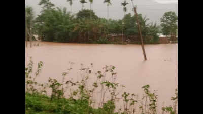
GUWAHATI: Nearly two lakh people in Assam have been hit and nearly 9000 of them have been forced to take shelter in relief camps as the situation due to the first wave of flood worsened on Tuesday. More than 220 villages in seven affected districts have been inundated.
The Central Water Commission (CWC) has issued an alert saying that Assam is in severe flood situation, which is expected to deteriorate further while the met department’s warning indicated ‘heavy to very heavy’ rainfall at isolated places in the state over the next five days.
The water commission in its tweet said, “River Brahmaputra at Neamatighat in #Jorhat District #Assam State continues in Severe Flood Situation with rising trend and is expected to rise further till tomorrow.”
In another alarming tweet the CWC said, “River Brahmaputra (main river) at Neamatighat #Jorhat District #Assam State is rising and flowing in Severe Flood Situation at 1300 hrs on 25th May 2020 and is likely to rise further.”
Out of the displaced population, who have been put up in relief camps, 8941 are in Goalpara district and rest 30 are in Tinsukia district, ASDMA stated.
The current first wave of flood struck on May 21. In last 24 hours the affected population has increased by over 70,000 from the affected population of 30,000 on Monday.
According to the CWC data, water levels in Naematighat station in Jorhat stood at 85.89 meters, which is over 0.8 meters above the danger level. Highest flooding level in the area is 87.37 meters which was last achieved on July 11, 1991.
Similarly, in Sonitpur and Baksa districts, the water levels have crossed the danger mark and are set to touch the highest flooding levels. The Beki road bridge station in Barpeta district recorded 44.7 meters water level, which is 0.6 meters above the warning level and 0.4 meters below the danger level.
At Manas HS crossing station in Barpeta district water level is at 48.36, 0.5 meters above the warning level and 0.1 meters below the danger level. Similarly, in Sonitpur and Baksa districts, the water levels have crossed the danger mark and are set to touch the highest flooding levels.
The Central Water Commission (CWC) has issued an alert saying that Assam is in severe flood situation, which is expected to deteriorate further while the met department’s warning indicated ‘heavy to very heavy’ rainfall at isolated places in the state over the next five days.

The water commission in its tweet said, “River Brahmaputra at Neamatighat in #Jorhat District #Assam State continues in Severe Flood Situation with rising trend and is expected to rise further till tomorrow.”
In another alarming tweet the CWC said, “River Brahmaputra (main river) at Neamatighat #Jorhat District #Assam State is rising and flowing in Severe Flood Situation at 1300 hrs on 25th May 2020 and is likely to rise further.”
Assam State Disaster Management Authority (ASDMA) stated that seven districts—Dibrugarh, Tinsukia, Lakhimpur, Dhemaji, Darrang, Nalbari and Goalpara have been affected so far. Goalpara district is the worst-hit where a population of 1,68,196 has been affected followed by 10,943 in Nalbari district, 7,897 in Dibrugarh district, 3455 in Tinsukia district, 2970 in Lakhimpur district, 845 in Darrang district and 610 in Dhemaji district.
Out of the displaced population, who have been put up in relief camps, 8941 are in Goalpara district and rest 30 are in Tinsukia district, ASDMA stated.
The current first wave of flood struck on May 21. In last 24 hours the affected population has increased by over 70,000 from the affected population of 30,000 on Monday.
According to the CWC data, water levels in Naematighat station in Jorhat stood at 85.89 meters, which is over 0.8 meters above the danger level. Highest flooding level in the area is 87.37 meters which was last achieved on July 11, 1991.
Similarly, in Sonitpur and Baksa districts, the water levels have crossed the danger mark and are set to touch the highest flooding levels. The Beki road bridge station in Barpeta district recorded 44.7 meters water level, which is 0.6 meters above the warning level and 0.4 meters below the danger level.
At Manas HS crossing station in Barpeta district water level is at 48.36, 0.5 meters above the warning level and 0.1 meters below the danger level. Similarly, in Sonitpur and Baksa districts, the water levels have crossed the danger mark and are set to touch the highest flooding levels.
About the Author
Prabin KalitaEnd of Article
FOLLOW US ON SOCIAL MEDIA


Hot Picks
TOP TRENDING
Trending Stories
In City
Entire Website
- Best 75 inch Smart TVs in India: Top Picks For A Premium Viewing Experience
- Lok Sabha Election 2024 Phase 1 Live Updates: Phase 1 will witness polling on 102 Parliamentary Constituencies
- Income Tax Calculator 2024-25: Which is better old or new regime? Check salary-wise, exemption & deductions calculation
- VVPAT: 'People with vested interest discrediting existing system'
- 'Dhoni last ball pe six maare, par...'
- In a first, US navy live tested a new missile during Iran's attack on Israel
- Rohit becomes only 2nd player to this IPL milestone
- AAP rejects ED's 'high-sugar food for bail' claim
- Indian national, 57, awaiting deportation dies in US hospital
- Dubai chaos continues: Record rainfall floods homes, halts flights
- Tamilisai vs Thangapandian: NDA allies pose challenges to DMK in key TN constituencies
- Lok Sabha elections: All set for phase 1 poll on 102 seats
- Who is this dreaded gangster hell-bent on killing Salman Khan?
- Lok Sabha Elections: Tamil Nadu all set to vote for 39 seats
- 2 Indian students found dead at Scottish sightseeing spot
- T20 World Cup: What is the best spot for KL Rahul?
- From techies to drivers, Japan has jobs for all kinds of Indian workers
- Google lays off more employees, moving some job roles to India
- Watch: Rohit Sharma and Shikhar Dhawan share a warm hug
- At 1.4%, Infosys sees lowest growth in its 43-year history

Popular Categories
Hot on the Web
Top Trends
Arvind Kejriwal NewsIPL Today MatchTamil Nadu Lok Sabha ElectionMI vs PBKS Live ScoreLok Sabha Election Phase 1Karnataka SSLC ResultIsrael Iran ConflictIPL Live ScoreBest AC Brands in IndiaInfosys Q4 resultsIPL Orange Cap 2024IPL Purple Cap 2024IPL 2024 ScheduleLok Sabha Election Full ScheduleIPL Points TableIPL Match Full Schedule
Trending Topics
Bade Miyan Chote Miyan CollectionSurya TilakDeepika PadukoneBalram Mattannur Death NewsRam Temples In IndiaDubai FloodSamarth JurelRam Lalla OutfitAnushka SharmaMasaba Gupta Pregnancy NewsShilpa ShettyJennifer Mistry Bansiwal Sister DeathDibakar BanerjeeArticle 370 OTT ReleaseHappy Relationship TipsNita AmbaniBest 1000 Litre Water TankBest Dishwashers In IndiaBest 75 Inch Smart TvBest Inverters For Homes
Living and entertainment
Latest News
Kairana: 2 epic tales & rise of a doughty daughterKairana: 2 epic tales & rise of a doughty daughterKairana: 2 epic tales & rise of a doughty daughterWhere will the Uttarakhandi go?Chief of NCB SIT that gave Shah Rukh Khan's son Aryan Khan a 'clean chit' in drugs case takes VRS on 'personal grounds'‘Risk to life’ makes voting tough exercise for displaced‘Risk to life’ makes voting tough exercise for displaced‘Risk to life’ makes voting tough exercise for displacedBullet to ballot: Manipur begins uneasy journeyBullet to ballot: Manipur begins uneasy journeyBullet to ballot: Manipur begins uneasy journeyWatch: Rohit Sharma and Shikhar Dhawan share a warm hug20 Syrian pro-government forces killed in IS attacks: MonitorIt seemed it would be an easy win for DMK, but looks like a challenge nowIt seemed it would be an easy win for DMK, but looks like a challenge nowThousands evacuated as Indonesia volcano erupts, causes tsunami threat2 jurors recuse from Trump hush money trial, one says 'intimidated'Divyanka Tripathi to undergo a surgery after she breaks two bones; informs husband Vivek Dahiya
Copyright © 2024 Bennett, Coleman & Co. Ltd. All rights reserved. For reprint rights: Times Syndication Service