- News
- City News
- nagpur News
- Melghat cell brings fire-hit areas down from 107 sqkm to 10 sqkm in 3 years
Trending
This story is from July 6, 2020
Melghat cell brings fire-hit areas down from 107 sqkm to 10 sqkm in 3 years
NAGPUR: Bringing down the area under forest fires from 10,764 hectares (107sqkm) to 1,000 hectares (10sqkm) in the last three years, the Melghat Tiger Reserve’s (MTR) fire cell in Amravati has become a role model for the forest department when it comes to controlling and monitoring forest fires.
MTR’s fire cell was set up in 2018 and is the first such cell in the state.The reserve also has the distinction of setting up a cyber crime cell. The cell has a dedicated staff comprising of a DFO, RFO and 10 forest guards.
Melghat expands over Amravati, Akola and Buldana districts and has five administrative forest divisions with Pandharkawda in Yavatmal being added this year. A report on the three-year fire monitoring in these areas was released on Thursday.
Before the cell started working, during the January-June 2018 fire season, in most vulnerable Sipna division, 4,838 hectare forest was gutted with 260 incidents, followed by burning of 2,221 hectare area through 220 cases in 2019. However, in 2020, 35 fire incidents were reported in which 169 hectare area only was devastated. Menacing fires drastically dropped at other divisions as well.
DFO Vishal Mali, the nodal officer of fire cell, said, “We get fire alerts from Forest Survey of India (FSI) and National Aeronautics & Space Administration (NASA). They share the location and maps in the form of latitude & longitude, which we put on forest maps to get the range, round and beat. This information was passed on by whatsapp to RFOs and the other field staff to respond quickly to the situation.”
About the preparation, Reddy said, “Even vehicles of RFOs were fitted with GPS and we used to track their vehicles to know the response time. The staff had undergone training last year at the ISRO office at Nagpur on how to download maps and images. We also deployed staff that was trained from Nagpur Fire College. Earlier, there was no such intensive monitoring.”
The lockdown reduced the number of fires. “To some extent, the less number of fire incidents was also due to the lockdown, but the role of the fire cell is vital. We also launched ‘Vanva Mukt Abhiyan’ in which villages were rewarded Rs1 lakh incentive for saving forest from fires. The money was used for village development,” said Reddy.
Mali said fire information alerts are almost near-time. It means that as soon as the satellite receives data, it is processed and sent to earth and later to user agencies within a short period of time, like 15 minutes. Even though it is impossible to contain the number of fire incidents due to diverse reasons and limited manpower, the area destroyed in the fire can be contained if doused beforehand with a quick response.
Dr Sivabala S, deputy conservator (DyCF), Sipna division, said, “In 2018, the percentage of forest fires was 29%. From 13.57% in 2019, we brought it down to just 1% by real-time monitoring. We also gave incentives to villagers for not letting forest fires spread.”
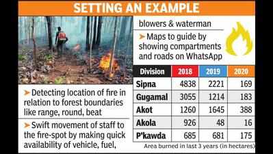
SETTING AN EXAMPLE
* Detecting location of fire in relation to forest boundaries like range, round, beat
* Swift movement of staff to the fire-spot by making quick availability of vehicle, fuel, blowers & waterman
* Maps to guide by showing compartments and roads on WhatsApp
Division 2018 2019 2020
Sipna 4838 2221 169
Gugamal 3055 1214 183
Akot 1260 1645 388
Akola 926 48 16
P’kawda 685 681 175
(Area burned in last 3 years)
MTR’s fire cell was set up in 2018 and is the first such cell in the state.The reserve also has the distinction of setting up a cyber crime cell. The cell has a dedicated staff comprising of a DFO, RFO and 10 forest guards.
Melghat expands over Amravati, Akola and Buldana districts and has five administrative forest divisions with Pandharkawda in Yavatmal being added this year. A report on the three-year fire monitoring in these areas was released on Thursday.
Before the cell started working, during the January-June 2018 fire season, in most vulnerable Sipna division, 4,838 hectare forest was gutted with 260 incidents, followed by burning of 2,221 hectare area through 220 cases in 2019. However, in 2020, 35 fire incidents were reported in which 169 hectare area only was devastated. Menacing fires drastically dropped at other divisions as well.
MTR APCCF & field director MS Reddy attributes the drop in fire incidents to real-time monitoring and quick response. “Melghat’s rugged terrain makes fighting forest fires a Herculean task. Controlling them is difficult as the location cannot be assessed. It is physically formidable to reach, but the fire cell made the job gradually easy,” said Reddy.
DFO Vishal Mali, the nodal officer of fire cell, said, “We get fire alerts from Forest Survey of India (FSI) and National Aeronautics & Space Administration (NASA). They share the location and maps in the form of latitude & longitude, which we put on forest maps to get the range, round and beat. This information was passed on by whatsapp to RFOs and the other field staff to respond quickly to the situation.”
About the preparation, Reddy said, “Even vehicles of RFOs were fitted with GPS and we used to track their vehicles to know the response time. The staff had undergone training last year at the ISRO office at Nagpur on how to download maps and images. We also deployed staff that was trained from Nagpur Fire College. Earlier, there was no such intensive monitoring.”
The lockdown reduced the number of fires. “To some extent, the less number of fire incidents was also due to the lockdown, but the role of the fire cell is vital. We also launched ‘Vanva Mukt Abhiyan’ in which villages were rewarded Rs1 lakh incentive for saving forest from fires. The money was used for village development,” said Reddy.
Mali said fire information alerts are almost near-time. It means that as soon as the satellite receives data, it is processed and sent to earth and later to user agencies within a short period of time, like 15 minutes. Even though it is impossible to contain the number of fire incidents due to diverse reasons and limited manpower, the area destroyed in the fire can be contained if doused beforehand with a quick response.
Dr Sivabala S, deputy conservator (DyCF), Sipna division, said, “In 2018, the percentage of forest fires was 29%. From 13.57% in 2019, we brought it down to just 1% by real-time monitoring. We also gave incentives to villagers for not letting forest fires spread.”
SETTING AN EXAMPLE
* Detecting location of fire in relation to forest boundaries like range, round, beat
* Swift movement of staff to the fire-spot by making quick availability of vehicle, fuel, blowers & waterman
* Maps to guide by showing compartments and roads on WhatsApp
Division 2018 2019 2020
Sipna 4838 2221 169
Gugamal 3055 1214 183
Akot 1260 1645 388
Akola 926 48 16
P’kawda 685 681 175
(Area burned in last 3 years)
End of Article
FOLLOW US ON SOCIAL MEDIA


Hot Picks
TOP TRENDING
Trending Stories
In City
Entire Website
- Best TVs of 2024: Ultimate Guide to the Top Models for All Your Viewing Needs
- Lok Sabha Election 2024 Phase 2 Live Updates: 89 constituencies to go to polls today
- Bengaluru Lok Sabha Election 2024 Phase 2 Live Updates: Bengaluru Metro extends metro service beyond scheduled time in view of Lok Sabha polls
- Kerala Lok Sabha Election 2024 Phase 2 Live Updates: With 194 contestants in fray, Kerala gears up for polls with over 2.75 cr voters
- IPL 2024 Orange Cap Update: RCB's Virat Kohli 1st, CSK's Ruturaj Gaikwad 2nd and DC's Rishabh Pant 3rd after match 41
- In Karnataka, 91-year-old woman dies minutes after casting vote
- SC rejects all petitions seeking 100% verification of VVPATs during elections
- General Elections 2024 generate up to 9 lakh temp jobs: Industry experts
- Record 56 candidates scored 100 percentile in JEE (Main); JEE (Advanced) qualifying cutoff for IIT admissions on a five-year high
- WhatsApp to Delhi HC: Will shut down in India if told to break encryption
- Phase 2 polls: Brisk voting in Tripura, Manipur; low turnout in Maharashtra, Bihar till 1pm
- 'SC order on VVPAT blow to those who wanted to loot ballot boxes'
- What rise and rise of Big Mac Index means for Indian equities
- Arms and ammunitions recovered during CBI raids in Bengal's Sandeshkhali
- B'luru in pics: Free dosa, moti laddu, juice on voting day
- SC rejects pleas seeking 100% EVM-VVPAT verification
- Modi made a promise to youth in 2014. Here's a reality check
- Delhi HC to WhatsApp on its 'threat' to exit India
- K'taka polls: Voter turnout 38.2% by 1pm
- Kerala elections: Polling agent dies in Kozhikode

Popular Categories
Hot on the Web
Top Trends
Nagaland Board ResultLok Sabha Election 2024 Phase 2Kerala Lok Sabha Election Phase 2Bengaluru Lok Sabha ElectionLok Sabha Election Phase 2 Full ScheduleDelhi Lok Sabha Election ScheduleKKR vs PBKS Match PredictionJEE MainsRajasthan Lok Sabha ElectionStock Market TodayIPL Orange Cap 2024IPL Purple Cap 2024IPL 2024 ScheduleLok Sabha Election Full ScheduleIPL Points TableIPL Match Full Schedule
Trending Topics
Ravi KishanEverest MasalaOptical IllusionRuslaan Movie ReviewMonthly Health HoroscopeShekhar SumanRathnam ReviewMonthly Career HoroscopeGovindaDance DeewaneRaw MangoShriya PilgaonkarArchana Puran SinghRadhika MerchantTik Tok Ban In USPreity ZintaBest Affordable Vacuum CleanersBest Headphones Under 1000Best Phones Under 35000Best Tv Of 2024
Living and entertainment
Latest News
In pics: Bengaluru hotels offer free dosa, moti laddu, and watermelon juice on election day18-year-old BJP worker found dead in West BengalBest TVs of 2024: Ultimate Guide to the Top Models for All Your Viewing NeedsChennai - Bitragunta train cancelledIPL 2024 Purple Cap Update: MI's Jasprit Bumrah 1st, RR's Yuzvendra Chahal 2nd and PBKS' Harshal Patel 3rd after match 41Gemini, Virgo, Libra, and other Zodiacs that make great teachersCongress gave Muslims quota via backdoor in Karnataka: ModiThe final schedule of Sivakarthikeyan's 'Amaran' commencesNephews suspect man of doing 'black magic' on them, axe him to deathAyushmann Khurrana shares the frame with Dua Lipa, Uma Thurman, and Kylie Minogue at TIME100 Gala - PicsDrive innovation from the front: Master the art of tech leadership with MIT xPRO's Post Graduate Certificate in Technology Leadership & Innovation programCal HC directs NIA to file report on clashes in Murshidabad over Ram Navami celebrationsSC verdict on VVPAT big blow to those who wanted to loot ballot boxes: PM ModiSpiderman, spiderwoman's titanic pose on bike lands them in police webDish TV has Smart+ idea to take on Airtel, Jio and Tata PlayTamannaah Bhatia starrer 'Odela 2' gears up for its second schedule shootRailways to run two north-bound special trains via Tamil NaduRRB window for exam fee refund opens: Check bank details update link and last date here
Copyright © 2024 Bennett, Coleman & Co. Ltd. All rights reserved. For reprint rights: Times Syndication Service