NASA sees rebirth of Tropical Storm Paulette

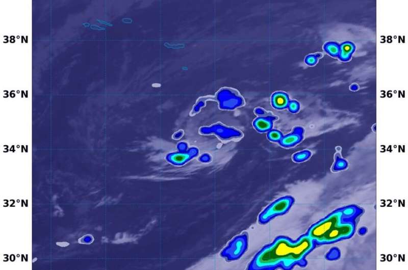
Tropical Storm Paulette just reformed in the central North Atlantic Ocean today, Sept. 22. Using a NASA satellite rainfall product that incorporates data from satellites and observations, NASA estimated Paulette's rainfall rates.
Paulette was a hurricane whose eye passed directly over Bermuda, then weakened and became a post-tropical cyclone on Sept. 16 in the North Atlantic Ocean when it was located 450 miles (725 km) east-southeast of Cape Race Newfoundland, Canada. A Post-Tropical Storm is a generic term for a former tropical cyclone that no longer possesses sufficient tropical characteristics to be considered a tropical cyclone.
At 11 a.m. EDT (1500 UTC) on Sept.16 NOAA's National Hurricane Center (NHC) issued the final advisory on Paulette but tracked its remnants over the last 6 days. NHC forecasters had assigned a medium chance that Paulette could redevelop over that time. At 11 p.m. EDT on Sept. 21 (0300 UTC on Sept. 22), Paulette regained tropical characteristics.
Paulette's Status on Sept. 22
At 5 a.m. EDT (0900 UTC) on Sept. 22, the center of Tropical Storm Paulette was located near latitude 34.7 degrees north and longitude 23.7 degrees west. That is about 295 miles (470 km) southeast of the Azores Islands. The Azores islands are an autonomous region of Portugal in the mid-Atlantic.
Paulette was moving toward the east-northeast near 17 mph (28 kph). An east or east-northeast motion at a slower forward speed is expected through Wednesday. Paulette is then expected to turn southward and southwestward Wednesday night and Thursday.
Maximum sustained winds are near 60 mph (95 km/h) with higher gusts. Weakening is forecast during the next couple of days, and Paulette is expected to become post-tropical by Wednesday night or Thursday. The estimated minimum central pressure is 1002 millibars.
Estimating Paulette's Rainfall Rates from Space
At 11 p.m. EDT on Sept. 21, deep convection and thunderstorm development associated with the post-tropical remnants of Paulette had become better organized over the past 6 to 12 hours. "An ASCAT over pass from a few hours ago indicate that increase in convective organization has resulted in strengthening and the system is being classified as a tropical cyclone once again," noted Daniel Brown, senior hurricane specialist and warning coordination meteorologist at NOAA's National Hurricane Center in Miami, Fla.
Four and a half hours later, NASA's Integrated Multi-satellitE Retrievals for GPM or IMERG, which is a NASA satellite rainfall product, estimated rainfall occurring in the newly reformed tropical storm. On Sept. 22 at 3:30 a.m. EDT (0730 UTC) IMERG formed Paulette was generating as much as 5 mm (0.20 inches) of rain per hour around the center of circulation.
By 5 a.m. EDT (0900 UTC), the NHC noted that the tops of Paulette's convective clouds have been warming since the previous advisory, and first-light visible images showed that a swirl of low- to mid-level clouds is about all that is left.
At the U.S. Naval Laboratory in Washington, D.C., the IMERG rainfall data was overlaid on infrared imagery from NOAA's GOES-16 satellite to provide a full extent of the storm.
What Does IMERG Do?
This near-real time rainfall estimate comes from the NASA's IMERG, which combines observations from a fleet of satellites, in near-real time, to provide near-global estimates of precipitation every 30 minutes. By combining NASA precipitation estimates with other data sources, we can gain a greater understanding of major storms that affect our planet.
What the IMERG does is 'morph' high-quality satellite observations along the direction of the steering winds to deliver information about rain at times and places where such satellite overflights did not occur. Information morphing is particularly important over the majority of the world's surface that lacks ground-radar coverage. Basically, IMERG fills in the blanks between weather observation stations.
NASA Researches Tropical Cyclones
Hurricanes/tropical cyclones are the most powerful weather events on Earth. NASA's expertise in space and scientific exploration contributes to essential services provided to the American people by other federal agencies, such as hurricane weather forecasting.
For more than five decades, NASA has used the vantage point of space to understand and explore our home planet, improve lives and safeguard our future. NASA brings together technology, science, and unique global Earth observations to provide societal benefits and strengthen our nation. Advancing knowledge of our home planet contributes directly to America's leadership in space and scientific exploration.
More information: For more information about NASA's IMERG, visit: pmm.nasa.gov/gpm/imerg-global-image
For forecast updates on hurricanes, visit: www.hurricanes.gov
Provided by NASA's Goddard Space Flight Center


