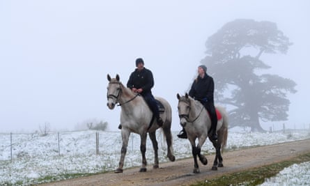
Springtime snow has fallen in parts of south-eastern Australia and a severe weather warning is in place as a cold front moves across New South Wales.
Damaging winds hit Sydney on Friday night, with winds of 115km/h recorded at Camden in the city’s south-west, while gusts reached 106km/h in the city.
A severe weather warning was in place on Saturday for damaging winds with gusts of more than 90km/h expected in the Illawarra and parts of the southern and central tablelands.
Snow fell around the NSW central and southern tablelands, including at Orange, Oberon and Barrington Tops, and higher parts of the Australian Capital Territory.
An afternoon of snow at the @soilcarbonco Orange office ❄️🌨 pic.twitter.com/jYRRa3U4yZ
— Tegan Nock (@TeganNock) September 25, 2020
About 20cm of snow fell in the alpine region overnight, with up to 40cm expected to drop during the weekend.
Snow also fell in parts of regional Victoria on Friday, including Ballarat, as temperatures dropped to almost zero in the middle of the day.

The Bureau of Meteorology NSW-ACT manager, Agata Imielska, said the cold front had brought cool conditions across much of the state.
“The feels-like temperature is likely to be 10C colder than the forecast temperature,” she told reporters.
For Sydney, this means the forecast of 19C will feel more like 8C or 9C during the day.
Imielska said the wind would gradually ease in the afternoon.
She warned driving conditions in parts of the state could be hazardous because of the weather and urged people heading out during the school holidays to be cautious.
The wintry blast was not rare for spring, which Imielska said brought “changeable conditions”.
“(This is a) classic example of warmer conditions ahead of a front bringing those very windy and cold conditions as the front moves through,” she said.
The cold blast was expected to be over fairly quickly, with temperatures to warm up on Sunday.
Despite the chilly weather in Sydney and southern NSW, the state’s north and far north coast were experiencing a very high fire danger on Saturday.
“Very dry and windy conditions have elevated fire conditions in the north coast,” Imielska said.
