- India
- International
Friday, Apr 26, 2024
Journalism of Courage
 The panel, headed by BJP MP Meenakshi Lekhi, contended unanimously that Twitter's explanation of showing Ladakh as part of China was "inadequate".
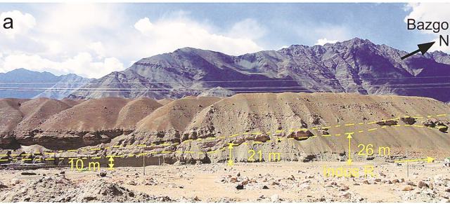
A RECENT survey has found that a tectonic fault line that runs through Ladakh, all along the Indus river, is not inactive as was previously thought and is, in fact, moving northward. The study by the Wadia Institute of Himalayan Geology, Dehradun, found that the fault line, the Indus Suture Zone (ISZ), is not “locked” and is tectonically active.
“While the frontal and central parts of the Himalayas — the Shivaliks, Himachal Pradesh, Uttarakhand, Jammu and Kashmir and Sikkim — are still known to be active and moving, the current understanding about the Ladakh region is that it was locked. Our survey has found that this is actually not the case and that the plate is still tectonically active. The fault line runs all along the Indus river, from China through India and Pakistan,’’ said co-author of the study, Koushik Sen.
Explained| Floods to plane crashes, the role National Disaster Response Force plays in India
A suture zone is a linear belt of intense deformation, where distinct terranes, or tectonic units with different plate tectonic, metamorphic, and paleogeographic histories, join together.
The study was conducted in Ladakh from the north of Ladakh’s capital, Leh, to the Tso Moriri lake, a distance of 213 kilometres. A low-intensity earthquake in 2010 near the village of Upshi in Ladakh, which falls on the fault line, can now be attributed to a thrust rupture, the study said.

The geologists observed that sedimentary beds in the area were tilted, the Earth’s crust broken, the rivers had uplifted terraces, and the bedrock showed brittle deformation that occurred at much shallower depths. These geological features were then dated in a laboratory at Dehradun using a technique called Optically Stimulated Luminescence and data of seismicity and the rate of denudation — or wearing away of the Earth’s surface — reviewed. The combination of field and lab data has found that the Indus Suture Zone has been neo-tectonically active for the past 78,000-58,000 years.
“While the fault line was ascertained in the late 1980s and early 1990s, it is only recently, with observatory stations being set up in more and more parts of the country, as well as advancement in technology, that we are able to ascertain and collect more information and data about the tectonic activity of existing fault lines which were earlier not known,’’ said Sen. The new finding could have major implications for earthquake study and in understanding the seismic structure of the mountain chains, he added.
Also Read| China insists Indians vacate Chushul heights, India says clear Pangong north
Sen, however, said that despite the fault line, the threat of a strong earthquake in the Ladakh region remained slim. “The possibility of a high magnitude earthquake here is almost non-existent because we have not picked up any intense seismic signature in the region,” he said.
But he struck a note of caution, saying that the implication of an active tectonic plate went far beyond earthquakes, and that it could make the region vulnerable to erosion and landslides.
“Fault lines weaken the rock formation in the region through which it runs, making the area vulnerable to excessive erosion and landslides. What makes the Ladakh region vulnerable is that unlike other areas in the Himalayas and the rest of the country, there is very little vegetation here and very few trees that can root the soil down. So, in the case of a flash flood or a cloud burst, this can have a widespread impact,” he said.
In August 2010, Ladakh experienced a devastating flood that affected 71 towns and villages, including Leh, killing 255 persons.

Engineering in local language sees uptick in students in UP,Subscriber Only
How Bengaluru’s lakes disappearedSubscriber Only

UPSC Key | Ethylene oxide, SIPRI Report, organ transplantsSubscriber Only

I met nobody in rural India who saw Modi asSubscriber Only

India’s trade with Israel & Iran, and impact of regionalSubscriber Only