- India
- International
Thursday, Apr 25, 2024
Journalism of Courage
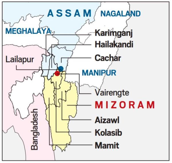
 The boundary between present-day Assam and Mizoram dates back to the colonial era, when Mizoram was known as Lushai Hills, a district of Assam. (Twitter/@ZoramthangaCM)
Over the last one week, residents of Assam and Mizoram have clashed twice over territory, injuring at least eight people and torching a few huts and small shops. It spotlights the long-standing inter-state boundary issues in the Northeast, particularly between Assam and the states that were carved out of it.
What were the recent clashes about?
On Saturday, residents of Lailapur village in Assam’s Cachar district clashed with residents of localities near Vairengte in Mizoram’s Kolasib district. On October 9, a similar clash took place on the border of Karimganj (Assam) and Mamit (Mizoram) districts.
On October 9, a farm hut and a betel nut plantation belonging to two Mizoram residents were set on fire. On Saturday, some people from Lailapur started pelting stones at Mizoram police personnel and Mizoram residents. “In turn, Mizoram residents mobilised and went after them,” Kolasib Deputy Commissioner H Lalthangliana said.
What led to this?
“According to an agreement between governments of Assam and Mizoram some years ago, status quo should be maintained in no man’s land in the border area. However, people from Lailapur broke the status quo and allegedly constructed some temporary huts. People from Mizoram side went and set fire on them,” Lalthangliana said. On the other hand, Keerthi Jalli, the DC of Cachar, told The Indian Express that the contested land belongs to Assam as per state’s records.
In the October 9 incident, according to Mizoram officials, the land claimed by Assam is being cultivated for a long time by residents of Mizoram. The DC of Mamit, Lalrozama, has urged that status quo be maintained. The Karimganj DC, Anbamuthan MP, said that although the contested land was historically cultivated by Mizoram residents, on paper it fell within the Singla Forest Reserve that is under Karimganj’s jurisdiction. Anbamuthan told The Indian Express that the issue was being resolved.

Mizoram borders Assam’s Barak Valley; both border Bangladesh. Mizoram civil society groups blame “illegal Bangladeshis” (alleged migrants from Bangladesh) on the Assam side. “Illegal Bangladeshis are creating all this trouble. They come and destroy our huts, cut our plants and this time pelted stones on our policemen,” said B Vanlaltana, president of the students’ union MZP (Mizo Zirlai Pawl).
How complex is the boundary dispute?
In the Northeast’s complex boundary equations, showdowns between Assam and Mizoram residents are less frequent than they are between, say, Assam and Nagaland residents. Nevertheless, the boundary between present-day Assam and Mizoram, 165 km long today, dates back to the colonial era, when Mizoram was known as Lushai Hills, a district of Assam.
The dispute stems from a notification of 1875 that differentiated Lushai Hills from the plains of Cachar, and another of 1933 that demarcates a boundary between Lushai Hills and Manipur.
A Mizoram minister told The Indian Express that Mizoram believes the boundary should be demarcated on the basis of the 1875 notification, which is derived from the Bengal Eastern Frontier Regulation (BEFR) Act, 1873. Mizo leaders have argued in the past argued against the demarcation notified in 1933 because Mizo society was not consulted. MZP’s Vanlaltana said the Assam government follows the 1933 demarcation, and that was the point of conflict.
The last time the boundary saw violence was in February 2018. The MZP had built a built a wooden rest house in a forest, its stated purpose being to serve as a resting for farmers. Assam police and forest department officials demolished it saying this was in Assam territory. MZP members clashed with Assam personnel, who also thrashed a group of Mizoram journalists who had gone to cover the incident.
📣 Click to follow Express Explained on Telegram
The boundary dispute between the two states has been simmering since the formation of Mizoram as a separate state in the 1980s. According to an agreement between governments of Assam and Mizoram some years ago, status quo should be maintained in no-man’s land in the border area. However, clashes have erupted from time to time over the issue.
What are the other boundary issues in the Northeast?
During British rule, Assam included present-day Nagaland, Arunachal Pradesh and Meghalaya besides Mizoram, which became separate state one by one. Today, Assam has boundary problems with each of them.
Nagaland shares a 500-km boundary with Assam. According to a 2008 research paper from the Manohar Parrikar Institute for Defence Studies and Analyses, violent clashes and armed conflicts, marked by killings, have occurred on the Assam-Nagaland border since 1965. In two major incidents of violence in 1979 and 1985, at least 100 persons were killed, The Indian Express has reported earlier. The boundary dispute is now in the Supreme Court.
On the Assam-Arunachal Pradesh boundary (over 800 km), clashes were first reported in 1992, according to the same research paper. Since then, there have been several accusations of illegal encroachment from both sides, and intermittent clashes. This boundary issue too is being heard by the Supreme Court.
The 884-km Assam-Meghalaya boundary, too, witnesses flare-ups frequently. As per Meghalaya government statements, today there are 12 areas of dispute between the two states. In February this year, the Chief Ministers of the two states spoke to each other about the need to maintain status quo and peace.
Engineering in local language sees uptick in students in UP,Subscriber Only
How Bengaluru’s lakes disappearedSubscriber Only

UPSC Key | Ethylene oxide, SIPRI Report, organ transplantsSubscriber Only

I met nobody in rural India who saw Modi asSubscriber Only

India’s trade with Israel & Iran, and impact of regionalSubscriber Only
EC likely to clear PM Modi's Ram Temple mention in rally as not violating Model Code of Conduct. Complaint filed by Supreme Court lawyer alleging violation of MCC by seeking votes in the name of Hindu and Sikh deities. EC found no violation and concluded that PM was listing government's achievements.