- India
- International
Friday, Apr 19, 2024
Journalism of Courage
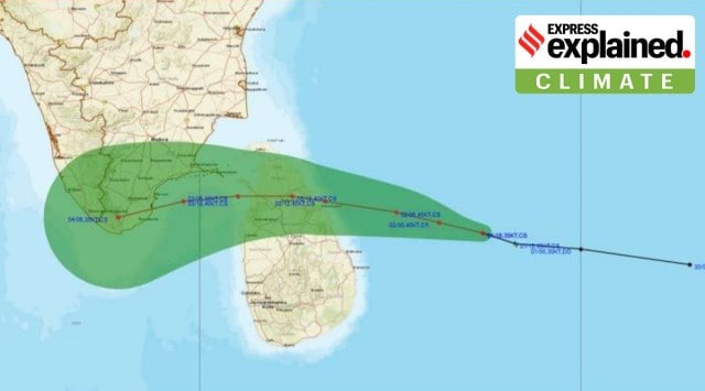 Cyclone Burevi is likely to cross between Kanyakumari and Pamban on Friday morning. (Source: IMD)
In exactly a week, another cyclone will brush Tamil Nadu coast, or its southernmost tip, to be precise. This is the third cyclone formed within the last 10 days in the Arabian Sea and the Bay of Bengal, put together. The India Meteorological Department (IMD) has warned of heavy rain for Tamil Nadu and Kerala till December 5.
Seven days after Cyclone Nivar hit the Karaikal coast, another cyclone, Burevi, named by the Maldives, is expected to cross Tamil Nadu’s southernmost district of Kanyakumari later this week.
At 8.30 am on Wednesday, the cyclone was located 200 km east of Trincomalee in Sri Lanka, 420 km east-southeast of Pamban and 600 km east-northeast of Kanyakumari in Tamil Nadu.
Under the influence of this cyclone, heavy to extremely heavy rain (over 204 mm) is forecast in Tamil Nadu and Kerala till December 5.
By Wednesday evening, the cyclone will intensify. As a cyclonic storm, Burevi is expected to first cross the Sri Lankan coast near Trincomalee some time during late Wednesday evening or night. Thereafter, it will trace a west-northwestwards track, reach Gulf of Mannar and inch closer to Indian mainland’s southernmost tip.

The Met department has forecast that Burevi will cross between Kanyakumari and Pamban as a cyclonic storm (wind speed 78 to 80 km/hour, gusting to 100 km/hour) during the afternoon hours of Friday.
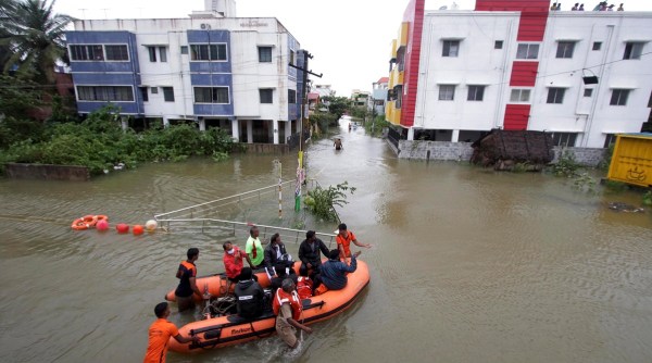 Rescuers help transport people stranded in floodwaters due to Cyclone Nivar, on the outskirts of Chennai, Thursday, Nov. 26, 2020. (AP Photo: R. Parthibhan)
Developed in the Bay of Bengal, the very severe cyclone Nivar, with wind speeds of 89 to 117 km/hr, had hit near Karaikal on November 25.
Unstable sea conditions, in the southwest region of Bay of Bengal, continue due to the recent crossing of Nivar. The overall sea conditions currently remain disturbed.
This is why meteorologists say there is a high possibility that Cyclone Burevi would not strengthen beyond the intensity of a cyclonic storm.
“Due to upwelling caused by Nivar, Cyclone Burevi will have limited intensity,” said an official from IMD.
When such consecutive systems develop in the same region of the ocean, the predecessor system leads to upwelling — the process in which cooler waters from lower ocean surfaces are pushed towards upper ocean surfaces.
In the absence of warm sea surface conditions, any cyclone, in this case Burevi, will not get enough fuel to intensify further while at sea.
The IMD has indicated that Burevi will remain a cyclonic storm (wind speed 62 to 88 km/hr) till December 5, before it weakens into a deep depression. 📣 Follow Express Explained on Telegram
Heavy to very heavy rainfall (64 to 204 mm) is forecast over Kanyakumari, Tirunelveli, Thoothukudi, Tenkasi, Ramanathapuram and Sivagangai districts of Tamil Nadu, and Thirvananthapuram, Kollam, Pathanamthitta, Alappuzha districts of Kerala mainly on December 2 and 3.
Extremely heavy rain (more than 204 mm) is expected at isolated places in these districts on Thursday.
Northern districts of Tamil Nadu, Puducherry, Lakshadweep and south coastal Andhra Pradesh will receive heavy rain till Saturday.
Squally winds with speeds ranging between 45–55 km/hr, gusting to 65 km/hr will be experienced off Tamil Nadu and Kerala coasts on Wednesday.
By Thursday, winds with speeds of 70 to 80 km/hr, gusting to 90 km/hr will blow over these southern districts, as the cyclone crosses over to land.
Don’t miss from Explained | Why has Northeast monsoon remained subdued this year?

Can UP interfaith live-in couples get police protection?Subscriber Only

Heart disease & maternal deaths: New ICMR study attempts toSubscriber Only

UPSC Key | FDI in space sector, heavy rainfall inSubscriber Only

S Y Quraishi on life after poll bonds: The nextSubscriber Only

The strategic importance of Andaman & Nicobar IslandsSubscriber Only

AAP Bharuch candidate's frontline fighters are his two wivesSubscriber Only

Is there hope for India’s dying wastelands?Subscriber Only

In Delhi refugee camp, a Nehru from Pak awaits citizenshipSubscriber Only
Jharkhand Academic Council (JAC) will declare the Class 10 results today (April 19) on their official websites. Students can access their scorecards by entering their login details on jac.nic.in, jharresults.nic.in, or jac.jharkhand.gov.in. The marksheet will include personal details, subject-wise marks, and a cumulative score. Last year, the pass percentage was 95.38%.