Srinagar: A vendor pushes his cart down a road during a cold and foggy morning, in Srinagar, Friday, Jan. 15, 2021. The Kashmir Valley is reeling under severe cold conditions as Srinagar recorded a low of minus 7.6 degrees Celsius.
Parts of north India remained under the grip of an intense cold wave on Sunday with night temperatures dropping below the 5 degrees Celsius-mark at some places and dense fog enveloping several areas. The minimum temperature in Delhi dropped to 5.7 degrees Celsius but it is likely to rise over the next two days due to a change in the wind direction, the India Meteorological Department (IMD) said.
The national capital will see shallow fog on Monday morning and light rain is likely to occur, the IMD said. The city’s minimum and maximum temperatures are expected to settle around 8 and 17 degrees Celsius.
An IMD official said easterly winds are blowing in Delhi that are not as cold as northwesterly winds coming in from the snow-clad western Himalayas. Hence, the minimum temperature is likely to rise by a few notches over the next two days.
Meanwhile, Delhi's air quality index (AQI) improved slightly to the 'very poor' category from 'severe' on Saturday as favourable wind speed helped in dispersion of pollutants.
READ MORE: 2020 was 8th warmest year since 1901: IMD
The city's AQI was 329 at 8.30 pm on Sunday. The 24-hour average AQI was 407 on Saturday, 460 on Friday, 429 on Thursday, and 354 on Wednesday.
An AQI between zero and 50 is considered 'good', 51 and 100 'satisfactory', 101 and 200 'moderate', 201 and 300 'poor', 301 and 400 'very poor', and 401 and 500 'severe'.
Intense cold wave conditions persisted in Kashmir, even as the minimum temperatures increased marginally across the valley.
The meteorological department said a western disturbance is likely to affect Jammu and Kashmir for a few days starting January 22, bringing snowfall and rain to the union territory.
The night temperature in Kashmir improved slightly but remained several notches below the freezing point, a Met department official said.
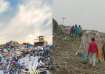
Srinagar city -- the summer capital of Jammu and Kashmir -- recorded a low of minus 7.6 degrees Celsius, up from minus 8.2 degrees Celsius the previous night, he said. Pahalgam, which also serves as a base camp for the annual Amarnath Yatra in south Kashmir, recorded a low of minus 8.7 degrees Celsius, up from the previous night's minus 9.4 degrees Celsius. Qazigund was the coldest place in Jammu and Kashmir with a minimum temperature of minus 9 degrees Celsius, the official said.
The intense cold wave in Kashmir has resulted in the freezing of water supply lines in several areas. A thick layer of ice has covered several roads, making it difficult for motorists to drive.
Several water bodies, including the famous Dal Lake, have also frozen. The State Disaster Response Force (SDRF) and river police are conducting patrolling around the frozen water bodies to ensure the safety of people.
Parts of Uttar Pradesh witnessed dense fog and cold day to severe cold day conditions prevailed at isolated places.
Churk in Sonbhadra district was the coldest place in the state with a minimum temperature of 4.6 degrees Celsius, it said.
Agra recorded a low of 6.3 degrees Celsius, followed by 6.6 degrees Celsius in Kanpur and 8.7 degrees Celsius in Jhansi.
The weather department said dense to very dense fog is very likely to occur in the morning at a few places in the state on Monday and cold day conditions are also very likely to prevail at isolated places over the state, it said.
Weather is most likely to remain dry in the state. Shallow to moderate fog is very likely to occur at isolated places over the state on Tuesday and Wednesday, it added.
Cold weather conditions continued to persist at many places in Haryana and Punjab with temperatures hovering below the normal limits.
According to the Met department, Narnaul in Haryana reeled under intense cold, recording a low of 2.5 degrees Celsius, three notches below normal limits.
Hisar, too, experienced a cold night at 3.4 degrees Celsius, down four notches, while Sirsa, Bhiwani and Rohtak registered below normal minimums at 4 degrees Celsius, 4.7 degrees, and 5.6 degrees respectively.
In Punjab, Bathinda recorded below normal minimum at 3.4 degrees, while Faridkot and Gurdaspur, too, recorded below normal lows at 5.
5 degrees and 7 degrees Celsius respectively.
Chandigarh, the common capital of the two states, recorded a low of 8.3 degrees Celsius.
During the past few days, maximum temperatures, too, have been hovering 6-10 notches below normal at most places in the two states and Chandigarh.
Meanwhile, the Met officials said that fog reduced visibility early in the morning at most places in the two states.
In Rajasthan, night temperatures dipped by a few degrees in parts and Pilani was the coldest place recording a temperature of .4 degrees Celsius followed by Churu which shivered at 1.9 degrees.
Dense fog also engulfed many parts of the state. Ganganagar, Jaisalmer, Bikaner, Alwar, Bundi and Dabok recorded 2.5, 6.1, 6.3, 7.4, 9.6 and 10 degrees respectively.
READ MORE: Rainfall likely in several parts of the country this month: IMD
RELATED VIDEO