Case data from before and after the third national lockdown shows the impact the measure has had - or not.
As the end of 2020 approached, infection rates in England reached new highs.
Whether due to people bending the rules over the festive period or the expected consequence of the cold weather forcing socialising inside, cases climbed steadily throughout December.
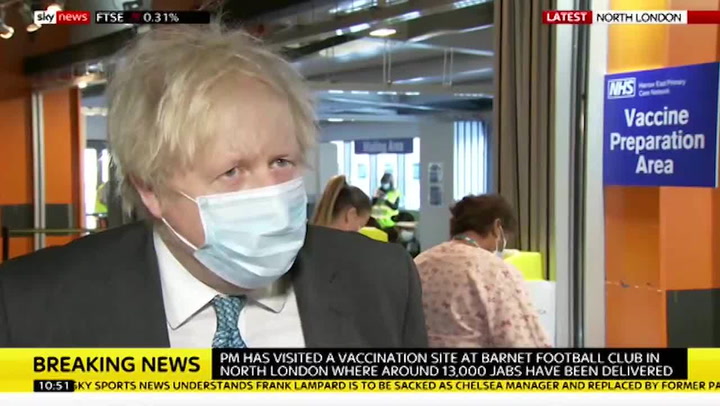
The alarmingly high number of positive tests being returned led Boris Johnson to call another England-wide lockdown, which came into force on January 5.
Almost three weeks on, the impact the tighter restrictions have had can be seen in the local coronavirus case rates.
What is the situation like where you live? Have your say in the comments section
The list below shows the current case rates for every local authority region in England, while next to it is the area's case rate just before the third national lockdown was brought in, for comparison (using what was the latest available data as of January 4, 2021).
The case rate is expressed as the number of new cases per 100,000 people and the list has been calculated based on Public Health England data published on the Government's coronavirus dashboard.
Scroll through the list below to see where your area ranks
In Knowsley in Merseyside, you can see the case rate is almost double what it was before lockdown.
The borough had been hard hit in the first wave of the pandemic and was the worst hit place for Covid-19 rates in October around the start of the second wave. Strict Tier 3 and Tier 4 restrictions saw numbers go down - but the winter wave has seen it shoot back to the top of the charts.
It may seem as though the third national lockdown is not having much of an effect in Knowsley - but the area does have various "vulnerabilities" which have seen it harder hit by the pandemic, according to Knowsley's Director of Public Health, Dr Sarah McNulty.
It is now an agreed fact that Covid-19 takes hold and wreaks more havoc in the most deprived communities, and Knowsley is one of the 20% most deprived local authority areas in the country. Around 27% - or 8,000 - of all children in the borough live in low income families.
Life expectancy for men and women is lower than the average in England and more people suffer with the kind of conditions that makes it harder to fight the virus.
Dr McNulty said: "We know we have high levels of respiratory disease, heart disease and all of those conditions that mean people are much less resilient when it comes to fighting off the more severe impacts of covid."
Knowsley also has a high proportion of industrial work places with employees who simply can't work from home.
As London and areas in the North began the pandemic at the top of the charts, Kent and Essex became two counties which were hardest hit in the second wave.
In Brentwood in Essex, it looks like lockdown is working a treat - as the case rate has dropped to 367.4 from 1,264.6 before the third national lockdown.
On December 26, Brentwood became the worst affected area in the whole of England after recording a surge in cases.
At that point, the local authority had an infection rate of 1,339.9 cases per 100,000 people in the week up to December 20.
Travel forward to today and Brentwood is not only far from the worst in England, but it also has the lowest infection rate in the entire county of Essex.
In St Helens in Merseyside, where the case rate is 746.5 - more than double what it was before the third national lockdown was brought in, when it was at 369.9.
St Helens’ director of public health Sue Forster, told a meeting of the People’s Board last week that households socialising over Christmas lead to a big jump in Covid cases in the New Year, with a “perfect storm” of factors leading to a post-Christmas spike.
The town is seeing cases spike in the over 80s, and care homes, while a number of younger children have been more impacted. While the Liverpool City Region moving into Tier 2 restrictions in December was something which "heavily impacted" the region, the health chief said - according to a report in the St Helens Star.
"What we’ve really got, or had, is the perfect storm. We’ve had a new variant and then socialising over Christmas," she added.
"And even through the restrictions were only for one day, we did definitely see the trend where it was a real increase just after Christmas."
The list in full
Here is the list in full. From left to right, it reads: Name of local authority, rate of new cases in the seven days to January 18, rate of new cases in the seven days to December 31 (in brackets).
Knowsley, 1014.8, (536.3)
Slough, 936.9, (993.1)
Sandwell, 898.5, ( 624.1)
Hounslow, 850.4, (1016.9)
Wolverhampton, 872.2, (717.7)
Newham, 817.3, (1257.3)
Barking and Dagenham, 822.4, (1476.2)
Brent, 831.5, (928.2)
Ealing, 841.4, (857.8)
Eastbourne, 821.2, (711.4)
Tendring, 781.2, (733.5)
Rushmoor, 802.3, (1125.8)
St Helens, 746.5, (369.9)
Halton, 761.1, (638.3)
Harlow, 748.8, (1251.9)
Carlisle, 743.5, (847.5)
Castle Point, 774.5, (1302.3)
Liverpool, 723.0, (457.4)
Bournemouth Christchurch and Poole, 721.9, (498.6)
Thurrock, 746.2 (1389.2)
Walsall, 741.6, (566.1)
Croydon, 702.1, (957.0)
Sefton, 743.8, (489.9)
Redbridge, 702.4, (1381.9)
Burnley, 692.8, (722.0)
Wirral, 723.1, (555.8)
Gravesham, 692.0, (1136.2)
Birmingham, 689.9, (521.3)
Luton, 688.6, (672.1)
Worcester, 687.6, (396.2)
Thurrock, 685.4, (685.4)
Dudley, 682.5, (509.6)
Hillingdon, 679.8, (905.9)
Sefton, 677.3, (489.9)
Waltham Forest, 676.9, (1057.5)
Castle Point, 676.1, (1302.3)
Greenwich, 672.7, (983.5)
Hyndburn, 668.8, (482.5)
Stevenage, 668.2, (752.5)
Wirral, 666.3, (555.8)
Bedford, 660.7, (736.9)
Crawley, 651.2, (830.9)
Lambeth, 646.6, (806.1)
Dartford, 646.5, (1159.8)
Harrow, 645.4, (912.2)
Enfield, 642.9, (1174.7)
Corby, 641.1, (480.5)
Northampton, 639.8, (634.9)
Sutton, 636.3, (1041.0)
Broxbourne, 635.3, (1302.4)
Reading, 631.1, (548.3)
Watford, 628.5, (973.3)
Derby, 621.8, (465.6)
Tower Hamlets, 621.4, (1140.0)
Havering, 616.4, (1187.8)
Lewisham, 609.5, (891.6)
Barnet, 606.5, (978.1)
Blackburn with Darwen, 605.9, (564.5)
Merton, 601.3, (979.4)
Pendle, 599.3, (579.7)
Haringey, 597.4, (986.4)
Hackney and City of London, 593.8, (862.7)
South Staffordshire, 592.3, (502.5)
Welwyn Hatfield, 591.7, (750.1)
Spelthorne, 589.9, (829.3)
Southend-on-Sea, 587.0, (1059.9)
Folkestone and Hythe, 583.2, (741.6)
Southwark, 581.5, (843.7)
Bexley, 578.8, (1157.5)
Leicester, 569.1, (427.7)
Woking, 561.5, (681.6)
Reigate and Banstead, 559.3, (725.4)
Milton Keynes, 558.9, (868.8)
Colchester, 558.3, (734.4)
Isle of Wight, 557.2, (677.1)
Mansfield, 539.7, (390.6)
Hammersmith and Fulham, 531.5, (696.2)
Norwich, 524.3, (457.4)
Bromsgrove, 521.6, (436.5)
Braintree, 520.3, (1028.2)
Hertsmere, 517.5, (995.1)
Arun, 516.3, (681.8)
Peterborough, 515.2, (443.0)
Medway, 513.7, (1058.0)
Telford and Wrekin, 513.2, (288.6)
Cannock Chase, 511.1, (495.2)
Coventry, 510.6, (401.1)
Bolsover, 510.2, (333.9)
Solihull, 508.8, (408.1)
Chelmsford, 507.9, (985.5)
Worthing, 506.5, (591.5)
Preston, 503.0, (306.0)
Middlesbrough, 501.5, (420.6)
Great Yarmouth, 501.3, (522.5)
Epsom and Ewell, 501.1, (791.3)
Portsmouth, 499.3, (604.9)
Basildon, 498.4, (1133.0)
Cherwell, 498.3, (692.3)
Epping Forest, 496.6, (1289.4)
Bromley, 495.9, (1046.2)
Wealden, 493.0, (578.4)
Oxford, 492.6, (441.4)
Wandsworth, 491.1, (725.9)
Warrington, 490.4, (521.4)
Ashfield, 490.2, (492.5)
East Staffordshire, 487.7, (484.3)
Barrow-in-Furness, 484.7, (293.8)
Thanet, 483.4, (624.3)
Adur, 482.1, (553.6)
West Lancashire, 476.8, (362.2)
Surrey Heath, 475.9, (740.2)
Erewash, 475.9, (306.8)
Lancaster, 472.5, (328.0)
Wycombe, 471.8, (602.4)
Tandridge, 469.8, (717.1)
Basingstoke and Deane, 468.9, (388.5)
Maldon, 468.2, (902.6)
Islington, 467.3, (725.0)
Ipswich, 463.8, (531.7)
Maidstone, 462.7, (805.5)
North Hertfordshire, 460.4, (457.4)
Kettering, 459.8, (342.9)
Rossendale, 458.9, (330.2)
Breckland, 458.7, (430.1)
Lewes, 453.2, (566.5)
Tamworth, 452.4, (316.8)
South Ribble, 451.3, (302.4)
Rochford, 451.0, (1014.1)
Ribble Valley, 450.0, (496.0)
Wychavon, 449.7, (316.8)
Southampton, 446.3, (584.1)
Ashford, 446.0, (797.5)
Hastings, 443.6, (792.1)
Wellingborough, 441.6, (358.8)
Hartlepool, 430.3, (699.3)
Dacorum, 429.0, (659.1)
Aylesbury Vale, 427.7, (591.6)
Havant, 427.0, (645.7)
North Warwickshire, 426.0, (358.5)
Kingston upon Thames, 420.8, (774.6)
Three Rivers, 420.0, (906.5)
East Hertfordshire, 420.0, (666.5)
Broadland, 419.0, (468.0)
Shropshire, 417.5, (241.7)
Chichester, 416.9, (424.3)
South Bucks, 416.9, (983.7)
Tonbridge and Malling, 414.7, (731.0)
Brighton and Hove, 413.2, (605.7)
Westminster, 412.1, (533.5)
Manchester, 411.5, (302.6)
Central Bedfordshire, 411.2, (594.8)
Redcar and Cleveland, 408.3, (287.3)
King's Lynn and West Norfolk, 407.6, (433.3)
Sunderland, 406.9, (444.7)
Blaby, 406.8, (347.7)
Amber Valley, 405.0, (467.4)
Runnymede, 404.8, (613.9)
Fenland, 404.5, (372.1)
Nottingham, 404.3, (345.7)
Sevenoaks, 404.1, (739.5)
Swale, 402.4, (745.6)
Bristol, 402.0, (339.0)
Copeland, 401.9, (247.9)
Kensington and Chelsea, 399.0, (589.9)
Allerdale, 397.9, (429.6)
Stafford, 393.4, (343.8)
Uttlesford, 392.2, (758.1)
Cheshire West and Chester, 390.6, (473.7)
Gosport, 390.2, (397.2)
Camden, 390.0, (609.9)
Rother, 388.2, (613.0)
Nuneaton and Bedworth, 388.0, (426.5)
Lichfield, 385.7, (366.6)
Eastleigh, 384.0, (467.9)
Guildford, 383.9, (543.0)
Chesterfield, 381.3, (232.6)
Stockton-on-Tees, 376.5, (352.2)
Waverley, 375.2, (599.2)
York, 375.1, (462.9)
Dover, 375.0, (503.7)
Daventry, 373.5, (465.4)
Bracknell Forest, 372.9, (774.4)
Somerset West and Taunton, 372.6, (425.5)
Wigan, 369.7, (332.0)
Broxtowe, 368.3, (317.5)
Rugby, 368.1, (437.9)
East Suffolk, 368.0, (335.5)
Brentwood, 367.4, (1264.6)
Wyre Forest, 367.3, (378.1)
Bolton, 365.8, (249.7)
North West Leicestershire, 365.8, (311.7)
Stoke-on-Trent, 364.3, (300.7)
South Derbyshire, 363.6, (337.5)
Salford, 362.0, (278.6)
Bury, 361.8, (334.0)
Stockport, 359.2, (329.6)
Fareham, 358.8, (501.6)
Hinckley and Bosworth, 358.0, (274.9)
Chorley, 355.3, (290.1)
Eden, 354.9, (625.3)
Mid Sussex, 353.6, (536.3)
Windsor and Maidenhead, 352.0, (672.3)
Mole Valley, 351.9, (483.7)
Gedling, 351.2, (358.8)
Elmbridge, 350.9, (703.2)
Gloucester, 350.0, (456.9)
South Gloucestershire, 349.4, (338.13)
Darlington, 348.3, (387.6)
Chiltern, 348.2, (511.8)
South Northamptonshire, 347.1, (526.0)
Trafford, 345.9, (346.7)
St Albans, 345.6, (708.6,)
Tameside, 345.3, (268.4)
Babergh, 344.4, (510.7
Hart, 344.1, (667.5)
Tunbridge Wells, 342.0, (470.0)
Wokingham, 336.0, (552.2)
South Norfolk, 335.7, (457.8)
Rochdale, 335.4, (290.9)
Huntingdonshire, 333.2, (450.1)
North East Derbyshire, 330.2, (289.8)
North Somerset, 328.3, (339.5)
Canterbury, 326.5, (512.7)
Richmond upon Thames, 325.7, (628.7)
Wyre, 324.7, (314.9)
Cambridge, 324.5, (499.2)
Test Valley, 321.0, (445.5)
Charnwood, 320.7, (272.33)
Plymouth, 319.7, (195.0)
Newark and Sherwood, 319.4, (276.1)
Oadby and Wigston, 319.2, (492.9)
Horsham, 315.7, (486.1)
County Durham, 315.0, (423.7)
Dorset, 311.2, (258.9)
Bath and North East Somerset, 309.9, (279.9)
Craven, 308.0, (329.0)
Cheshire East, 308.0, (408.2)
Sedgemoor, 307.7, (448.1)
New Forest, 306.5, (299.9)
Lincoln, 304.1, (339.4)
Malvern Hills, 302.4, (207.1)
Selby, 301.3, (317.8)
High Peak, 301.1, (224.5)
West Suffolk, 300.5, (375.3)
East Hampshire, 300.1, (377.7)
South Holland, 299.9, (257.8)
Mid Suffolk, 297.4, (357.1)
Herefordshire, 297.2, (274.4)
Hambleton, 295.9, (367.9)
Wiltshire, 295.4, (264.0)
East Northamptonshire, 295.2, (301.5)
South Tyneside, 294.7, (456.4)
Fylde, 294.6, (238), 330.5, (267)
Warwick, 292.9, (243.98)
Newcastle-under-Lyme, 292.8, (272.7)
Harrogate, 292.2, (268.6)
Swindon, 291.6, (499.6)
South Kesteven, 291.4, (392.5)
South Lakeland, 287.4, (236.0)
Gateshead, 287.1, (379.1)
Leeds, 284.7, (269.4)
Mendip, 283.8, (234.5)
Rotherham, 283.0, (266.4)
Rushcliffe, 282.8, (306.2)
Oldham, 282.6, (272.4)
Bradford, 279.7, (217.5)
Harborough, 279.3, (400.8)
Ryedale, 278.1, (292.5)
Newcastle upon Tyne, 277.4, (197.5)
West Berkshire, 277.1, (389.4)
Blackpool, 276.8, (253.1)
Richmondshire, 275.5, (422.5)
North Norfolk, 273.8, (367.2)
South Cambridgeshire, 272.8, (433.1)
Northumberland, 272.6, (328.4)
Winchester, 272.3, (472.5)
Doncaster, 267.7, (286.0)
Stratford-on-Avon, 264.4, (311.3)
Vale of White Horse, 258.1, (383.8)
South Oxfordshire, 257.6, (505.4)
East Cambridgeshire, 257.1, (401.8)
North Kesteven, 247.2, (296.8)
Kirklees, 242.8, (228.7)
Melton, 242.1, (291.0)
Sheffield, 238.7, (225.7)
Barnsley, 236.6, (271.0)
Cornwall and Isles of Scilly, 236.4, (298.7)
South Somerset, 234.6, (248.3)
Wakefield, 232.8, (253.2)
Staffordshire Moorlands, 230.6, (224.5)
Forest of Dean, 230.4, (362.9)
West Lindsey, 224.7, (253.0)
Exeter, 222.2, (197.9)
Bassetlaw, 219.7, (275.0)
West Oxfordshire, 219.6, (354.3)
Tewkesbury, 218.9, (243.1)
Hull, 217.5, (293.3)
Teignbridge, 214.7, (144.6)
Torbay, 214.3, (119.6)
Rutland, 207.9, (220.4)
Calderdale, 206.7, (243.6)
Derbyshire Dales, 197.7, (200.5)
North Tyneside, 195.3, (238.1)
Cheltenham, 190.0, (233.9)
Cotswold, 182.5, (258.2)
Boston, 182.4, (222.3)
West Devon, 179.2, (123.7)
Scarborough, 178.4, (326.4)
East Riding of Yorkshire, 175.3, (207.5)
East Devon, 161.3, (157.2)
South Hams, 159.8, (147.1)
Mid Devon, 151.9, (204.1)
North Lincolnshire, 145.7, (220.0)
Stroud, 142.5, (240.1)
East Lindsey, 119.2, (161.6)
North East Lincolnshire, 111.6, (150.4)
North Devon, 69.0, (123.5)
Torridge, 58.6, (101.1)