- News
- India News
- Times face-off: Will the proposed Ken-Betwa project solve the region’s water woes or destroy livelihoods and ecosystems? Experts are sharply divided
Trending
This story is from May 7, 2021
Times face-off: Will the proposed Ken-Betwa project solve the region’s water woes or destroy livelihoods and ecosystems? Experts are sharply divided
AB Pandya (FOR)
With uneven rain, river linking only way to ensure equitable distribution of water
Interlinking of rivers will help the country fulfill its dream of ensuring equitable distribution of water and, thereby, prosperity for all. There have been several such steps in this direction, and in 1980 a National Perspective Plan was formalised. This involved transfer of water from water-surplus basins to water-deficit basins/regions in which 30 links were identified.Somehow, the term ‘river interlinking’ stuck in the public imagination though its real name could have been the National Inter- Basin Water Transfer Project.
So why do we need to link rivers? Though India receives about 4,000 BCM (billion cubic meters) of precipitation annually, utilisable resources are only 1,123 BCM. Even these are not distributed evenly in space or time. Most of the precipitation occurs in about 90 days in a year and the distribution of annual average availability ranges from 510 BCM for Ganga, 527 BCM from Brahmaputra and 11.02 BCM for Pennar and 12.06 BCM for Sabarmati. This shows the skew between potential demands and availability. It has, therefore, been recognised that the inter-basin transfer of water is the only recourse for making an equitable distribution of water across the country and thereby ensuring equal opportunities of development.
Critics of this concept propound myths like massive rehabilitation requirements, environmental damage etc but these are all based on conjecture rather than reality. One of the crucial features of the project is location of reservoirs in areas with very low population density with only the canals running in agricultural areas.
More than connecting multiple rivers like an electricity grid, the project aims at serving irrigation to the lower commands and transferring the corresponding surplus waters from upper commands to the neighbouring basin. We do not have an extreme disparity in terms of flora and fauna between neighbouring basins in peninsular India. Hence, this talk of mixing of waters and invasion of foreign species etc are not founded in any reality. Existing water transfers have also not indicated any such effects.
There is a clamour about the disruption of climate due to such transfers. Once again, the same is purely conjectural as the impacts required to be created for such a climate change versus the actual transfers envisaged are tiny. As an example, the total yield of Ganga and Brahmaputra combined in Bay of Bengal is more than 1,000 BCM whereas the diversion is likely to be no more than 40 BCM annually and that too will ultimately result in reaching Bay of Bengal due to land topography. In any case, the linkage between any of the basins and their outlets into the seas are not being modified.
On the other hand, the proposals can provide 172 lakh hectares of annual irrigation which, considering an average farm size of one hectare, can benefit 17.2 million farmer families and possibly 86 million people. In addition, 780 million can get assured drinking water supply. Surface water in water scarce areas will stop unsustainable groundwater utilisation as well. Thus, the benefits far outweigh costs. The question as to why such beneficial schemes are not yet getting implemented is due to our internal wrangling.
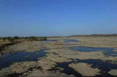
Ken Betwa happens to be the first link which was identified for implementation. It will benefit the perennially water-short Bundelkhand region and other associated regions of Bina and upper Betwa basins. Besides irrigation and drinking water, it will generate 103 MW of hydropower and 27 MW solar power. Like any other infrastructure project, KBLP will also have some environmental and resettlement and rehabilitation (R&R) issues. Daudhan reservoir will cause submergence of about 9,000 ha land of which 5,800 ha is forest land.
However, with a comprehensive environment management plan (EMP), compensatory afforestation and liberal R&R policy, these impacts will be taken care of. A comprehensive landscape management plan is also being prepared for the conservation of Panna Tiger Reserve. Even wildlife will get sustenance in hot summers with assured water supply from the reservoir. The reservoir remaining at relatively low level will expose large tracts of land allowing fodder to be grown, benefitting the lower rung of wildlife which, in turn, can support the whole pyramid.
The project will provide year-round employment in Bundelkhand region, controlling forced migration to far flung areas for livelihood. The assured drinking water supply will also uplift health standards of the local populace.
AB Pandya is Secretary General, International Commission on Irrigation and Drainage
Rohan D'Souza (AGAINST)
Our quest to control rivers doesn’t account for the stiff ecological cost
At first glance, the Interlinking Rivers Programme (ILRP) offers great appeal. India is generously endowed with a sprawling river system but though bounteous and generous, these rivers are whimsical: prone to recurring floods, bone-dry droughts and with vast volumes winding circuitously before wastefully emptying into the sea.
Enter the engineer with a grand vision. Why not link India’s river network through dams, diversions and barrages, while impounding much of their flows within giant reservoirs that are connected? Then wire this mix of concrete and steel infrastructure with software involving a couple of equations, data sets, sensors and the ingenuity of some hard hat engineers and, soon enough, all the rivers can be put on tap. That is, capture the surplus flows of a river and transfer it to a water deficit or stressed region. This, in fact, is the best argument put forward for the Ken-Betwa link.
On closer scrutiny, however, this fantastical and elegant ILRP notion falls flat. The disconnect between idea and reality, in fact, plays out at three levels.
First, the entire project rests on a wrong assumption. There is no such thing as a river with a ‘surplus flow’. Since the 1980s, studies under the broad field of ‘river ecology’ have convincingly established that a river cannot be defined as ‘lots of water’ in a channel. Rather, every river is a fluvial highway that connects flora and fauna across and between floodplains, wetlands, deltas and estuaries. In sum, it delivers innumerable environmental services such as creating fish habitats, replenishing soil, sustaining biodiversity and sculpting land through erosion and deposition.
Seasonal variability floods or low flows are vital to enabling the river to constantly evolve its rich diversity of ecological relations. The Brahmaputra or the Ganga, for example, should therefore be understood not as massive flows but as a collection of ecological relations and environmental services. If a river is thus a biological regime, then it cannot have a surplus flow.
If the principal assumption is clearly wrong, it should also come as no surprise when a second order of complications follows from the first. Notably, the flawed reasoning that often goes with making economic calculations for the project. It is now fairly well known that many if not every big dam or large-scale irrigation project in India has a tendency to get their cost and benefit ratios mostly muddled. To a great extent, this is because economics as a discipline continues to have a hard time developing methodologies that can meaningfully capture ecological costs. This gets even messier when grappling with plotting future scenarios.
Consequently, for all the assumed benefits of irrigation and electricity from large dams, the long-term impacts from water logging, salinity or the loss of fisheries have yet to be meaningfully added up. That is, no reliable assessment has thus far been carried out that can meaningfully tell us whether over 70 years of large-scale water infrastructure development were worth the ecological costs.
But the wrong assumption and flawed reasoning that haunts the ILRP is actually indicative of a far more profound and fatal limitation. Recent scholarship, mostly by historians, has ably described how water infrastructure and management in post Independent India has tended to retain a strong colonial engineering mindset. The earliest version of the ILRP was, in fact, first championed in the 1850s by the famed colonial engineer and irrigator General Sir Arthur Cotton.
Titled the Peninsular Scheme, Cotton’s plan was to build navigation canals that would link Karachi (now in Pakistan) to Madras (Chennai) via Kanpur, Kolkata and Cuttack with additional lines crawling upwards to Pune. In terms of rivers, this meant connecting the Indus to the Ganga with canals before dropping the latter steeply to the South to link up with the Mahanadi, Krishna, Godavari and finally the Cauvery. And if such a vast navigation network could be built, the General then confidently concluded, there would be no need for the railways in British India.
Though Cotton’s Peninsular Scheme came to grief, the colonial quest for river control remains. Notably in the poorly understood claim that rivers are mere flows that need to be regulated and can be put to work by dams, barrages, weirs, embankments and canal systems. Starkly missing in the picture is how we make sense of the river as a complex biological pulse.
Does this mean that rivers should never be engineered? No.
The argument is for ‘smart engineering’, which is a rapidly evolving approach in Europe. Smart engineers build projects that are in active dialogue with social scientists, ecologists and specially those who specialise in design. Cement and contractor engineering can no longer address ecological complexity and the ILRP is the last surviving dinosaur in that tradition. If the coming challenges of water shortages and extreme flood events are to be meaningfully dealt with, then Indian engineering has to embrace new knowledge and be inventive enough to enable a productive conversation between science, ecology, history, sociology and art. A river, after all, is more than just water.
D’Souza is Professor, Graduate School of Asian and African Area Studies, Kyoto University
With uneven rain, river linking only way to ensure equitable distribution of water
Interlinking of rivers will help the country fulfill its dream of ensuring equitable distribution of water and, thereby, prosperity for all. There have been several such steps in this direction, and in 1980 a National Perspective Plan was formalised. This involved transfer of water from water-surplus basins to water-deficit basins/regions in which 30 links were identified.Somehow, the term ‘river interlinking’ stuck in the public imagination though its real name could have been the National Inter- Basin Water Transfer Project.
So why do we need to link rivers? Though India receives about 4,000 BCM (billion cubic meters) of precipitation annually, utilisable resources are only 1,123 BCM. Even these are not distributed evenly in space or time. Most of the precipitation occurs in about 90 days in a year and the distribution of annual average availability ranges from 510 BCM for Ganga, 527 BCM from Brahmaputra and 11.02 BCM for Pennar and 12.06 BCM for Sabarmati. This shows the skew between potential demands and availability. It has, therefore, been recognised that the inter-basin transfer of water is the only recourse for making an equitable distribution of water across the country and thereby ensuring equal opportunities of development.
Inter-basin water transfer is not a new concept and there have been many such successful examples in the country. It has been practised in our country since 1887 when the Mulla Periyar dam was built and waters of the west-flowing river basin were transferred to east flowing Vaigai basin transforming agricultural development in and around Madurai for about 68,000 hectares. Just ask any one in Madurai about the role this water plays in their lives. Similarly, we have already made trans- basin transfers in case of the Beas Satluj link, Sardar Sahayak pariyojana, Sardar Sarovar project, Kurnool Cudddapah canal etc which are functioning well. In the US, the Colorado-Big Thompson project has been functioning since the 1930s and has contributed greatly to the economy of Colorado state.
Critics of this concept propound myths like massive rehabilitation requirements, environmental damage etc but these are all based on conjecture rather than reality. One of the crucial features of the project is location of reservoirs in areas with very low population density with only the canals running in agricultural areas.
More than connecting multiple rivers like an electricity grid, the project aims at serving irrigation to the lower commands and transferring the corresponding surplus waters from upper commands to the neighbouring basin. We do not have an extreme disparity in terms of flora and fauna between neighbouring basins in peninsular India. Hence, this talk of mixing of waters and invasion of foreign species etc are not founded in any reality. Existing water transfers have also not indicated any such effects.
There is a clamour about the disruption of climate due to such transfers. Once again, the same is purely conjectural as the impacts required to be created for such a climate change versus the actual transfers envisaged are tiny. As an example, the total yield of Ganga and Brahmaputra combined in Bay of Bengal is more than 1,000 BCM whereas the diversion is likely to be no more than 40 BCM annually and that too will ultimately result in reaching Bay of Bengal due to land topography. In any case, the linkage between any of the basins and their outlets into the seas are not being modified.
On the other hand, the proposals can provide 172 lakh hectares of annual irrigation which, considering an average farm size of one hectare, can benefit 17.2 million farmer families and possibly 86 million people. In addition, 780 million can get assured drinking water supply. Surface water in water scarce areas will stop unsustainable groundwater utilisation as well. Thus, the benefits far outweigh costs. The question as to why such beneficial schemes are not yet getting implemented is due to our internal wrangling.
Ken Betwa happens to be the first link which was identified for implementation. It will benefit the perennially water-short Bundelkhand region and other associated regions of Bina and upper Betwa basins. Besides irrigation and drinking water, it will generate 103 MW of hydropower and 27 MW solar power. Like any other infrastructure project, KBLP will also have some environmental and resettlement and rehabilitation (R&R) issues. Daudhan reservoir will cause submergence of about 9,000 ha land of which 5,800 ha is forest land.
However, with a comprehensive environment management plan (EMP), compensatory afforestation and liberal R&R policy, these impacts will be taken care of. A comprehensive landscape management plan is also being prepared for the conservation of Panna Tiger Reserve. Even wildlife will get sustenance in hot summers with assured water supply from the reservoir. The reservoir remaining at relatively low level will expose large tracts of land allowing fodder to be grown, benefitting the lower rung of wildlife which, in turn, can support the whole pyramid.
The project will provide year-round employment in Bundelkhand region, controlling forced migration to far flung areas for livelihood. The assured drinking water supply will also uplift health standards of the local populace.
AB Pandya is Secretary General, International Commission on Irrigation and Drainage
Rohan D'Souza (AGAINST)
Our quest to control rivers doesn’t account for the stiff ecological cost
At first glance, the Interlinking Rivers Programme (ILRP) offers great appeal. India is generously endowed with a sprawling river system but though bounteous and generous, these rivers are whimsical: prone to recurring floods, bone-dry droughts and with vast volumes winding circuitously before wastefully emptying into the sea.
Enter the engineer with a grand vision. Why not link India’s river network through dams, diversions and barrages, while impounding much of their flows within giant reservoirs that are connected? Then wire this mix of concrete and steel infrastructure with software involving a couple of equations, data sets, sensors and the ingenuity of some hard hat engineers and, soon enough, all the rivers can be put on tap. That is, capture the surplus flows of a river and transfer it to a water deficit or stressed region. This, in fact, is the best argument put forward for the Ken-Betwa link.
On closer scrutiny, however, this fantastical and elegant ILRP notion falls flat. The disconnect between idea and reality, in fact, plays out at three levels.
First, the entire project rests on a wrong assumption. There is no such thing as a river with a ‘surplus flow’. Since the 1980s, studies under the broad field of ‘river ecology’ have convincingly established that a river cannot be defined as ‘lots of water’ in a channel. Rather, every river is a fluvial highway that connects flora and fauna across and between floodplains, wetlands, deltas and estuaries. In sum, it delivers innumerable environmental services such as creating fish habitats, replenishing soil, sustaining biodiversity and sculpting land through erosion and deposition.
Seasonal variability floods or low flows are vital to enabling the river to constantly evolve its rich diversity of ecological relations. The Brahmaputra or the Ganga, for example, should therefore be understood not as massive flows but as a collection of ecological relations and environmental services. If a river is thus a biological regime, then it cannot have a surplus flow.
If the principal assumption is clearly wrong, it should also come as no surprise when a second order of complications follows from the first. Notably, the flawed reasoning that often goes with making economic calculations for the project. It is now fairly well known that many if not every big dam or large-scale irrigation project in India has a tendency to get their cost and benefit ratios mostly muddled. To a great extent, this is because economics as a discipline continues to have a hard time developing methodologies that can meaningfully capture ecological costs. This gets even messier when grappling with plotting future scenarios.
Consequently, for all the assumed benefits of irrigation and electricity from large dams, the long-term impacts from water logging, salinity or the loss of fisheries have yet to be meaningfully added up. That is, no reliable assessment has thus far been carried out that can meaningfully tell us whether over 70 years of large-scale water infrastructure development were worth the ecological costs.
But the wrong assumption and flawed reasoning that haunts the ILRP is actually indicative of a far more profound and fatal limitation. Recent scholarship, mostly by historians, has ably described how water infrastructure and management in post Independent India has tended to retain a strong colonial engineering mindset. The earliest version of the ILRP was, in fact, first championed in the 1850s by the famed colonial engineer and irrigator General Sir Arthur Cotton.
Titled the Peninsular Scheme, Cotton’s plan was to build navigation canals that would link Karachi (now in Pakistan) to Madras (Chennai) via Kanpur, Kolkata and Cuttack with additional lines crawling upwards to Pune. In terms of rivers, this meant connecting the Indus to the Ganga with canals before dropping the latter steeply to the South to link up with the Mahanadi, Krishna, Godavari and finally the Cauvery. And if such a vast navigation network could be built, the General then confidently concluded, there would be no need for the railways in British India.
Though Cotton’s Peninsular Scheme came to grief, the colonial quest for river control remains. Notably in the poorly understood claim that rivers are mere flows that need to be regulated and can be put to work by dams, barrages, weirs, embankments and canal systems. Starkly missing in the picture is how we make sense of the river as a complex biological pulse.
Does this mean that rivers should never be engineered? No.
The argument is for ‘smart engineering’, which is a rapidly evolving approach in Europe. Smart engineers build projects that are in active dialogue with social scientists, ecologists and specially those who specialise in design. Cement and contractor engineering can no longer address ecological complexity and the ILRP is the last surviving dinosaur in that tradition. If the coming challenges of water shortages and extreme flood events are to be meaningfully dealt with, then Indian engineering has to embrace new knowledge and be inventive enough to enable a productive conversation between science, ecology, history, sociology and art. A river, after all, is more than just water.
D’Souza is Professor, Graduate School of Asian and African Area Studies, Kyoto University
End of Article
FOLLOW US ON SOCIAL MEDIA


Hot Picks
TOP TRENDING
Trending Stories
In India
Entire Website
- Best 75 inch Smart TVs in India: Top Picks For A Premium Viewing Experience
- JAC 10th Results 2024 Live: Jharkhand board Matric result today on jacresults.com
- Two states: Husband-wife pair from same PSU conquers IIM-A & IIM-B
- UPSC 2023 Topper's Mock Essay Goes Viral, Sparking Debate on Exam Relevance
- Man kills ex-girlfriend in Bengaluru park, her mom bludgeons him to death
- World's best airports list
- 2 prisoners rape woman inmate in jail van in Haryana; booked
- 'Aur inhe Champions Trophy host karni hai': With rain and no roof, Pakistan cricket fans forced to go under plastic sheets for shelter
- India tests indigenous tech long-range cruise missile
- Watch: Rohit Sharma and Shikhar Dhawan share a warm hug
- Israel-Iran war: Iran says Israeli drones shot down, 'no missile attack for now'
- Violence reported in Bengal as phase 1 voting begins
- By shielding BJP MLA, is the state encouraging hate speech?
- Iran's nuclear facilities unharmed: Key points
- LS polls: Tamil Nadu reports 12.55% voter turnout by 9 am
- 2 dead in suicide attack on vehicle carrying Japanese nationals in Karachi
- As India's hard power grows, its soft power takes a beating
- Read TCS CEO's ‘thanks letter’ to employees and COO
- Sensex plunges 600 points to below 72,000; Nifty around 21,800
- Watch: Bumrah can be swept for six, Ashutosh shows how

Popular Categories
Hot on the Web
Top Trends
Jasprit BumrahArvind KejriwalJAC 10th ResultTamil Nadu Lok Sabha ElectionIsrael Iran War NewsLok Sabha Election Phase 1Karnataka SSLC ResultStock MarketIPL Live ScoreBest AC Brands in IndiaIPL Orange Cap 2024IPL Purple Cap 2024IPL 2024 ScheduleLok Sabha Election Full ScheduleIPL Points TableIPL Match Full Schedule
Trending Topics
Bade Miyan Chote Miyan CollectionAR RahmanDeepika PadukoneBalram Mattannur Death NewsRam Temples In IndiaDubai FloodSamarth JurelRam Lalla OutfitAnushka SharmaMasaba Gupta Pregnancy NewsShilpa ShettyJennifer Mistry Bansiwal Sister DeathDibakar BanerjeeArticle 370 OTT ReleaseHappy Relationship TipsNita AmbaniBest 1000 Litre Water TankBest Dishwashers In IndiaBest 75 Inch Smart TvBest Inverters For Homes
Living and entertainment
Latest News
Voters prevented from carrying mobile phones in Chennai polling centrePBKS vs MI: Mumbai Indians' captain Hardik Pandya fined Rs 12 lakhJEE Main 2024 Session 2 Final Answer Key Expected Soon: Here's How to CheckJEE Main 2024 Session 2 Final Answer Key Expected Soon: Here's How to CheckNow, a Kerala Story by pro-Sangh bodyHanuman Jayanti 2024: When is Hanuman Jayanti? Know Correct Date and SignificanceHospital conducts 150 deliveriesa month without gynaec departmentCountdown to TCS World 10K Bengaluru beginsStray Kids set the stage for 'Lose My Breath' featuring Charlie Puth with teaser schedule2 dead in suicide attack on vehicle carrying foreigners in KarachiAnupamaa Spoiler: Shruti to be shot while trying to save Anupamaa?Rahul Gandhi targets Pinarayi again, Rajnath Singh mocks 'Rahulyaan'Candidates Chess: Vidit, Pragg almost out of contention after defeats to Nepo and Nakamura respectivelyIran and Israel's open warfare after decades of shadow war4 ways of cooking broccoli to reap the health benefitsRaj Kundra-Shilpa Shetty in Rs 6600 crore Bitcoin ponzi scam; businessman REACTS with cryptic postBigg Boss 14’s Nikki Tamboli mourns her friend's death; says, 'I’d pay anything to have you back'It’s not done & dusted
Copyright © 2024 Bennett, Coleman & Co. Ltd. All rights reserved. For reprint rights: Times Syndication Service