- India
- International
Wednesday, Apr 24, 2024
Journalism of Courage
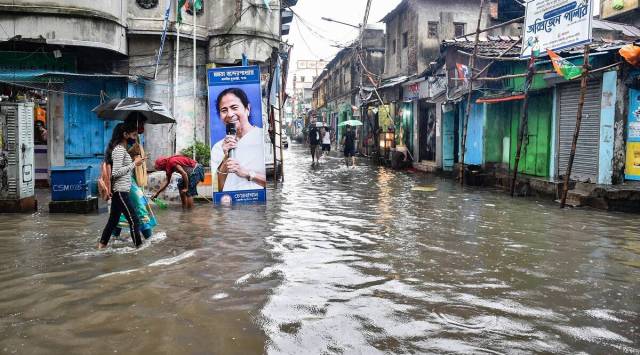 Pedestrians walk past a banner of West Bengal CM Mamata Banerjee on a waterlogged road during heavy rain in Kolkata. (PTI/File)
THE METEOROLOGICAL department has forecast “enhanced rainfall activity” over the districts of Sub-Himalayan West Bengal on Thursday.
According to officials, under the influence of low pressure area over coastal Odisha and adjoining Northwest Bay of Bengal, strong southerly winds from Bay of Bengal to northeast India will continue to prevail.
Rain or thundershower very likely to occur at most places over the districts of Sub-Himalayan West Bengal during the 19th. The weather department has issued an orange alert for Darjeeling, Kalimpong, Jalpaiguri, Alipurduar and Coochbehar districts of Sub-Himalayan West Bengal. Heavy to very heavy rain (07-20cm) is very likely to occur at one or two places over these places, the department said.
Yellow alert has been issued for several other places. Heavy rain (07-11 cm) is likely to occur at one or two places over North Dinajpur district of Sub-Himalayan West Bengal.
Weather department has also alerted authorities concerned of rise in water level in rivers, water logging in low lying municipal areas, damage of kuchha road and damage of standing vegetable crop. Landslides are likely in Darjeeling and Kalimpong districts, officials warned.

Kolkata and other parts of West Bengal have witnessed heavy downpour over the past few weeks. Heavy rain lead to waterlogging at several places and disruption of rail and road transport services.
On Wednesday, the Alipore meteorological department also forecast thunderstorms and rain (West Bengal Weather. The list includes Darjeeling and Jalpaiguri in North Bengal. Two 24 Parganas districts of South Bengal, two Medinipurs, Purulia, Bankura, two Bardhamans will also receive heavy thundershowers. However, heavy rains are unlikely in Kolkata. The meteorological office said thunderstorm will occur due to low pressure and seasonal axis.