- India
- International
Thursday, Apr 18, 2024
Journalism of Courage
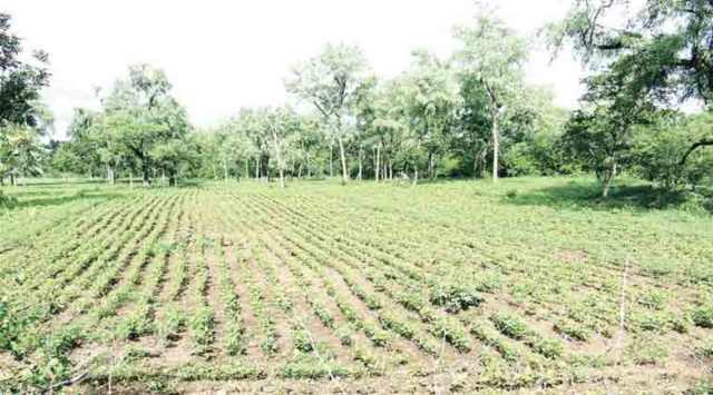 The government has roped in the Odisha Space Application Centre (ORSAC), a state body for space tech applications, to map the crop areas through satellite.
After facing state-wide protests from farmers over alleged irregularities in paddy procurement, the Odisha government is trying to create a database of “genuine” paddy cultivators by mapping crop area and production through satellite imagery and matching it against existing records.
A pilot project has been launched in seven of the state’s 30 districts — Sambalpur, Bargarh, Subarnapur, Bolangir, Nuapada, Kalahandi and Koraput.
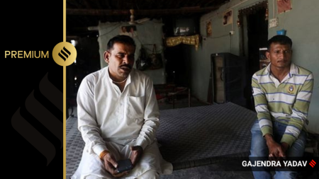
“We had received a lot of fake registrations under the online paddy procurement automation system. This, too, had led to confusion and certain kinds of irregularities. Through mapping, we will be able to remove fake cultivators and not issue any tokens in their names so that actual farmers are able to participate in procurement without hassle,” said Food Supplies and Consumer Welfare Minister Ranendra Pratap Swain.
Swain was referring to an online token system that has drawn the ire of many farmers. They had complained that their tokens lapsed before they could sell their produce in the procurement centres at MSP. This forced them to sell in open markets below the MSP. All this happened in a year (2020-21) Odisha produced surplus paddy. The government maintained that it had procured more than its capacity.
The government has roped in the Odisha Space Application Centre (ORSAC), a state body for space tech applications, to map the crop areas through satellite. The images will be geo-referenced with survey maps and records to identify land owners.

State officials said they discovered people in a few districts showing non-agricultural lands as cultivable land. Through remote sensing, they even found out that the registered land included forests, residential plots, grazing land and ponds. So far, ORSAC has identified over 26,000 ineligible plots. For instance, through remote sensing in Koraput, 1,465 names were deleted from the registered farmers list.
“Though at a preliminary level ineligible farmers are removed, it is important that the final list is genuine as well. This exercise will help us eliminate ineligible farmers,” said Swain.
Explained: Weeding out ‘fake’ paddy farmers
Under the Aadhaar-linked online token system which started in 2020, 14.97 lakh farmers registered themselves to sell paddy. After getting a token, the farmer is given a month to sell paddy at a procurement centre at MSP. Many registrations are removed due to document discrepancies. But through remote sensing, the state plans to weed out those who have provided false land records and are not genuine cultivators.

S Y Quraishi on life after poll bonds: The nextSubscriber Only

The strategic importance of Andaman & Nicobar IslandsSubscriber Only
AAP Bharuch candidate's frontline fighters are his two wivesSubscriber Only
UPSC Key: EVM, ballot paper, digital infrastructure and moreSubscriber Only

Is there hope for India’s dying wastelands?Subscriber Only
In Delhi refugee camp, a Nehru from Pak awaits citizenshipSubscriber Only

Iran-Israel conflict could cast shadow on India’s oil tradeSubscriber Only
The story of party symbols in Indian electionsSubscriber Only

Do Korean creams really work on Indian skin?Subscriber Only

The BJP candidate from the Hyderabad Lok Sabha constituency, Kompella Madhavi Latha, has courted controversy after a video of her gesturing to shoot an arrow, purportedly in the direction of a mosque, came to light. Latha was participating in a Ram Navmi procession near Siddi Junction in old Hyderabad, and riding an open-top vehicle.