
 "The Weather Report: Chennai, Bengaluru to see decrease in rainfall; rains make Srinagar cooler")
North East India continues to receive good monsoon rains during the past week, overall a reduction in extreme rainfall events have been observed but the region continues to remain flooded due to excessive rains earlier in June.
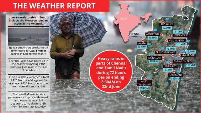
Meanwhile June records tumble in South India as the monsoon remains active in the peninsula. Bengaluru Airport breaks the all time record for the wettest June by recording 235.4 mm of rainfall for the month till date. The previous record was 231.8 mm in June 1996.
Similarly Chennai rains have picked up in the past week making it the historical June rains in the last three decades.
Heavy rains in parts of Chennai and Tamil Nadu during 72 hours period ending 8:30 am on 22 June:
Ambattur – 194mm KK Nagar – 189mm Taramani – 185mm Red Hills – 173mm Anna University – 167mm Avadi – 167mm West Tambaram – 166mm Mylapore – 163mm Villivakkam – 163mm Perambur – 161mm Anna Uty ARG – 159mm Nungabakkam – 158mm
Strong monsoonal flow is also observed in parts of West coast of India but Mumbai and adjoining areas are only witnessing on and off light to moderate rains. Santacruz Observatory recorded 36mm rainfall ending 8:30am on 25 June whereas Colaba experienced very light rains of 2mm on Saturday morning defining the scattered nature of the monsoon rains so far in this season leading to water shortage in the region. BMC announced a 10 per cent water cut owing to inadequate rainfall in the catchment area lakes in the month of june so far as the existing water stock levels drops below 10 per cent.
Earlier in the week a strong Western Disturbance resulted in above normal rainfall in the Himalayas and snowfall over extreme higher reaches of Kashmir and Himachal Pradesh.
Plains of North West including the thar desert region also experienced good Pre Monsoon rains hence the heatwave is completely abated from most parts of the country.
Anyhow, the past three days have been dry in Rajasthan, Haryana, Punjab, Delhi NCR and parts of Uttar Pradesh resulting in rise in maximum temperature across the region. Various stations in the states have recorded maximum temperatures close to 40°C but typical heatwave conditions are missing.
Under the influence of strong Western Disturbance and moisture pushed from Arabian sea resulted in heavy rains and Localised flooding in parts of Kashmir.
Batote recorded 121.4mm rainfall in the period of 24 hours on 22 June. This is highest ever single day rainfall recorded in month of June breaking the previous record of 121.0mm from 25 June 2015.
Excess rains resulted in winter-like chill in Srinagar City as it recorded lowest maximum temperature of June (at least since 1980).
Maximum temperature in Srinagar was 15.0°C (14.2°C below normal) on 21 June, 2022. The last time on 4 June 2015, Srinagar recorded 15.2°C and 16.0°C on 13 June 1994.
Along with the rains, cool northwest wind has swept parts of North West India plains from the hills in a winter like pattern. Churu in Rajasthan recorded 18.8°C minimum temperature on 22 June. It is the lowest minimum temperature in the month of June at least in the past decade. The all-time record is 17.7°C from 10 June 1974.
As per Indian Meteorological Department, the Northern Limit of Monsoon (NLM) continues to pass through Lat. 22°N/ Long. 60°E, Lat. 22°N/ Long. 65°E, Porbandar, Baroda, Shivpuri, Rewa, Churk. The further advancement of monsoon towards North West India has stalled for the last two days.
As per IMD data, total monsoon seasonal rains in India since 1 June till 25 June are as follows:
• India as a whole recorded a total of 120.8mm rainfall against the average of 126.9mm, departure from normal Stands at -5 per cent.
• Southern Peninsula: Actual 113.5mm against the average of 131.7mm, -14 per cent departure from normal.
• East & North East India: Actual 327.3mm against the average of 260.5mm, +26 per cent departure from normal.
• North West India: Actual 52.4mm against the average of 55.3mm, -5 per cent departure from normal.
• Central India: Actual 89.6mm against the average of 126.2mm, -29 per cent departure from normal.
The overall monsoon rains performance improved this week as the pan India rainfall departure came down to -5 per cent from -8 per cent from last Saturday.
All India Weather Forecast till 2nd July:
North India
Weather Synopsis:
• Dry North West Winds across North India till 27 June
• Moist Easterlies 27 June onwards
• Shift of Monsoon Axis/Trough towards North India from 28 June onwards
The weather conditions are very likely to stay dry in most parts of Punjab, Haryana, Delhi NCR, Rajasthan, Western UttarPradesh, Uttarakhand, Himachal Pradesh and Jammu Kashmir till 27 May under the influence of dry Northwest winds.
The flow of Monsoon i.e., easterly winds along with the movement of monsoonal trough will start shifting towards North West India from 28th June onwards.
Under the influence, scattered to fairly widespread rains will occur in Uttar Pradesh, Uttarakhand from during 27 to 29 June commencing the monsoon onset in the region.
The East to West moving rains to impact Delhi NCR, Haryana, Punjab, Himachal Pradesh and parts of East Rajasthan during the period of 29 June to 2 July. Monsoon onset should be declared in the region during this time as parameters look satisfactory for Monsoon deceleration. Meanwhile rain intensity seems to be moderate at the time of onset.
Overall the beginning of monsoon over North India will be on time but not likely to be strong, might pick in July only. The soaring temperatures will come down once again to mid 30 levels along with significant fall in minimum temperatures, afternoons will be humid and uncomfortable.
Expected precipitation accumulation till 2 July:
• Uttarakhand – 70mm • Uttar Pradesh – 60mm • Himachal Pradesh – 50mm • Delhi NCR – 40mm • Haryana – 40mm • Rajasthan – 20mm • Punjab – 20mm
Central India
Weather Synopsis:
• Developing inland low pressure area in Central India
The monsoon has covered Maharashtra, Chhattisgarh, East Central Madhya Pradesh. Some parts of Madhya Pradesh and Most parts of Gujarat are yet to receive the first spell of monsoon showers.
As per current analysis a cyclonic circulation is present over Jharkhand will remain stranded for next two days and may start moving West and develop into a inland low pressure area around next mid week.
Under the influence of the following weather system, monsoon is expected to advance in more parts of North Madhya Pradesh next week. The spread of monsoon rains might cover parts of East Gujarat by the next weekend.
Most parts of Chhattisgarh, Madhya Pradesh, Vidarbha, Marathwada and Madhya Maharashtra are likely to experience good monsoon rains under the influence of low-pressure area may boost the sowing of paddy crops in the rice bowl of the country. Due to the pull effect, the offShore trough will also strengthen in the North konkan. The rains are expected to increase in Mumbai and adjoining Ghat section, periods of widespread light to moderate rains are expected throughout next week along with scattered heavy showers.
Expected precipitation accumulation till 2nd July:
• Maharashtra – 110mm • Chhattisgarh – 90mm • Madhya Pradesh – 70mm • Gujarat – 40mm
East India
Weather Synopsis:
• The eastern arm of monsoon trough is present over the foothills of sub-Himalayas
• Moisture feeding south Westerly winds from the Bay of Bengal.
The relentless over the North East India will continue over the next week as the weather conditions look supportive. Light to moderate rains are expected in most parts of Arunachal Pradesh, Assam, Sikkim, Nagaland, Tripura, Manipur, Mizoram.
Parts of Sikkim, Meghalaya and sub-Himalayan west bengal may experience heavy to very heavy rainfall till 28 June and decrease thereafter. Overall extremely heavy rainfall events will be less next week.
As the monsoon axis will start shifting south from 28th June it will enhance rainfall across West Bengal, Bihar, Jharkhand, Odisha in the period of 28 June to 2 July, the subdued monsoonal conditions in East India will activate.
Expected precipitation accumulation till 2 July:
• North East India – 140mm • Bihar – 90mm • Jharkhand – 80mm • West Bengal – 80mm • Odisha – 60mm
South India
Weather Synopsis:
• Strengthening Offshore trough across West coast of Peninsula
• Cyclonic circulation around North Andhra Pradesh
As the off-shore trough is strengthening over the west coast of India, most parts of Goa, Karnataka, Kerala coasts and Western Ghats are likely to experience a very wet week ahead. Multiple days of heavy rains are to be observed in the region during the upcoming week as the weather models predict a positive anomaly.
Once the monsoon activates over the West coast the interior convective rains decrease significantly which is a proven fact in the Southern Peninsula and hence major Bangalore rains will be largely missing for most days in the next week except the overcast and micro drizzles which might stay.
The Chennai rains which have been very active in the past week are also expected to decrease significantly over the next week.
The presence of cyclonic circulation over North Andhra Pradesh and Telangana will help the region attract monsoon rains over the week, plenty of moderate rains will be observed in many parts of the states over the upcoming week.
Expected Precipitation accumulation till 2 July:
• Goa – 190mm • Karnataka – 140mm • Kerala – 110mm • Andhra Pradesh – 80mm • Telangana – 70mm • Tamil Nadu – 20mm
The author, better known as the Rohtak Weatherman, interprets and explains complex weather patterns. His impact-based forecasts @navdeepdahiya55 are very popular in north India.
Read all the Latest News , Trending News , Cricket News , Bollywood News , India News and Entertainment News here. Follow us on Facebook , Twitter and Instagram .


 "The Weather Report: North India braces for winter as mercury dips; cyclonic storm to form in central Bay of Bengal")
 "Weather Report: Agriculturists optimistic as rains revive in September")
 "Weather report: After a record-dry August, hopes are high for September")
 "Weather Report: August to end on record dry note, but September hopes revival of monsoon")